Cellspin in the field
Today I trialled an application that I think could be brilliant for fieldwork. Cellspin is downloadable to a variety of mobile phones and basically allows me to send photos, text, video and audio directly to my blog, twitter, youtube and other social sites. On trial, evident in the previous posts which were authored in a car park at Inveruglas after a walk today, the pictures are more impressive than the standard blogger uploads as you get a larger image without having to play around with the html. The image (as with the one I uploaded) is also automatically rotated. The text appears nicely beneath the picture (although I couldn't title my post, at least, I don't think) as the entries are grouped by date, and I also managed to send a status update to twitter through it too. I'm thinking this would be a great way to record a trip using different media types- Videos for peer assessment, audio to analyse geographical description, text as a field logbook, 140 characters to summarise key features of a field location and photos to evaluate field sketches? I know not all students would be able to download this, but it would be nice to give a trial run to this in a real fieldwork situation soon. My only gripe would be that the application seems to stay open permanently. This might just be a phone bug or it might be me being tech incompetent!
I also had another go with everytrail for Ben Vane. I noticed that the trail was mostly accurate, but seemed to lose transmission about 100 metres from the summit, and also only recorded the trip one way despite me keeping the application running till we arrived back at our start point. I can't explain the summit, but I think the one way recording might be because we duplicated the path on the way down? I also geotagged my flickr photos, but they were all over the place. Tonight, I think I've worked out how to get my everytrail trips to accept the photos as they are taken, but unfortunately too late for today, so flickr snaps will have to do.
Ben Vane at EveryTrail
Map created by EveryTrail:GPS Geotagging
Ben Vane at EveryTrail
Map created by EveryTrail:GPS Geotagging
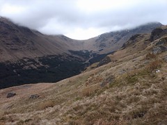
I also saved a couple of images from Google Earth for my walking buddy, and again was drawn to how excellent Gavin Brock's Ordnance Survey overlay for Google Earth can be for teaching maps. This picture of a corrie from our walk is the classic horsehoe or bowl shape:
To help students visualise this, all that's needed is the location in Google Eartha nd Gavins overlay. This could be such a big help to students, especially with exams approaching, for testing their map skills knowledge:
To help students visualise this, all that's needed is the location in Google Eartha nd Gavins overlay. This could be such a big help to students, especially with exams approaching, for testing their map skills knowledge:

posted by Kenny O'Donnell @ 11:31 pm
![]()


1 Comments:
Thanks for trying out www.everytrail.com by GlobalMotion Media, Inc. I work for this company and want to make myself available to bloggers like you who are writing about us.
I am confident I know what the problem is with the geolocations on your flickr'd photos. If you are in the "edit descriptions" for your photos (on everytrail.com), then drag the balloon of one photo to the right place on the map. Click the balloon and you will have an opportunity to base the locations of all other photos on that properly placed one. Take that opportunity and they'll all be done at once.
I hope this is helpful. Let me know if I can do more. You might also alert your readers to the fact that they can use everytrail's social network to follow your activities there.
thanks again for posting to everytrail and writing about it on your blog, dan AT globalmotion DOT com
Post a Comment
<< Home