Back to the Playroom

Categories: Rural Land Resources, Advanced Higher, s1 and s2
Been thinking about Higher tomorrow, after another missed period today (this time not work related). I have marked the Lithosphere interim tests and although the marks are good, there are some statements in papers which are, in football speak, hitting the crossbar. I've taken 12 lines from papers which represent either common errors or common 'nearly there's, and I am setting a 'How would you?' exercise at the start of the period- How would you change these lines to get extra credit out of them? This is not about highlighting your mistakes, but helping me get round everyone to improve your answers, and showing you in some instances how little that would actually take. I am still getting used to the promethean board after using an RM for nearly four years, but if I could capture the screen and stick the results up here, this will serve you well for revision.
I also might reprise another exercise from a while back. One of the questions which wasn't answered well was the one where you were asked to describe the difference between coastlines of erosion and deposition-far too much explaining going on. I remember having a similar problem two years ago with a Biosphere question, and I got students to record their answers. This could be done by mobile (perhaps then bluetoothed) or by using my laptop. The results last time were interesting as students a) suddenly realised how obvious some of their errors were just from listening back, errors that they were not seeing as they were writing, and b) when set to time, recall had to be concise. After this, it's onto the Dales, and the start of another case study...
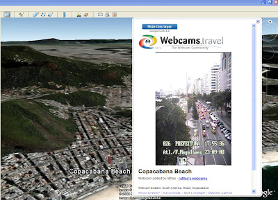
Finally back in the Geography rooms with s1. In many ways, where we were was better, being in the newer building with one class, but I was missing my toys ;-) Will finally be able to use Google Earth, great for the Brazil topic, but also for general interest. I found a great world webcams link from Wycombe High school, and this reminded me that you can now open a webcam layer in Google Earth. Might let s1 do a bit of exploring tomorrow, like I've been doing in the image above.
Last, but not least, Advanced Higher are working on Ardentinny write up, a really good opportunity for use of some of the Google Earth and Google Maps uses for Geographical Study. I think I'll rotate who has a go at this, and we'll share the results.


0 Comments:
Post a Comment
<< Home