<body><script type="text/javascript"> function setAttributeOnload(object, attribute, val) { if(window.addEventListener) { window.addEventListener('load', function(){ object[attribute] = val; }, false); } else { window.attachEvent('onload', function(){ object[attribute] = val; }); } } </script> <div id="navbar-iframe-container"></div> <script type="text/javascript" src="https://apis.google.com/js/platform.js"></script> <script type="text/javascript"> gapi.load("gapi.iframes:gapi.iframes.style.bubble", function() { if (gapi.iframes && gapi.iframes.getContext) { gapi.iframes.getContext().openChild({ url: 'https://www.blogger.com/navbar.g?targetBlogID\x3d23069377\x26blogName\x3dOdblog\x26publishMode\x3dPUBLISH_MODE_BLOGSPOT\x26navbarType\x3dBLUE\x26layoutType\x3dCLASSIC\x26searchRoot\x3dhttps://geodonn.blogspot.com/search\x26blogLocale\x3den_GB\x26v\x3d2\x26homepageUrl\x3dhttp://geodonn.blogspot.com/\x26vt\x3d8160912104340948054', where: document.getElementById("navbar-iframe-container"), id: "navbar-iframe", messageHandlersFilter: gapi.iframes.CROSS_ORIGIN_IFRAMES_FILTER, messageHandlers: { 'blogger-ping': function() {} } }); } }); </script>

Odblog

A weblog designed to share Geography resources with students and colleagues

Tuesday, November 30, 2010

The Big Yin teaching Tundra

Categories: Other
When I was looking through resources for teaching Tundra, I found an old text which had quite a lot of detail about people and developments in the Biome. It had a lot of facts about the traditional way of life for the Inuit, such as making soup from seals blood! Some 'recent' changes were detailed in the way of life of the Inuit and much of this still seemed relevant. However, I was a little wary of using such an old resource and felt I had to compliment it with something else. Enter Billy Connolly. In the boot of my car, I had a copy of 'Journey to the edge of the world', the book of the television series. After looking on youtube, I found a couple of appropriate clips but, in truth, I could have used many more. The first clip below was really useful. For instance, today, we talked about the settlement that serves as the backdrop and why there appeared to be no road. It was easy to illustrate how the built environment is also sensitive to the needs of the landscape, with houses raised off the ground. The climate for August looks a tad chilly too :-)

The second clip had scenes that some people might find a little upsetting, as Billy followed a family in a 'traditional' hunt, which actually perfectly illustrated how, even when clinging to traditions, the outside world has influenced the Inuit. Both clips supported the lesson really well and I would use them again.

Sunday, November 28, 2010

At first it's cold, and then it's hot...

Categories:s1 and s2, Glaciation, Other
A weekend of snow has resulted in a bit of brainfreeze regarding where I'm at and what I'm supposed to be doing with my classes tomorrow. With S4, we are beginning a look at the Tundra. I started on Thursday with an inflatable globe. I've done this before and always have a smile to myself at the reaction when I say 'yes' to the inevitable question, 'Sir, are we playing with that today?'. We use the globe and wherever the thumb of the right hand lands, the student has to correctly identify whether it is Tundra, Hot Desert, Polar, Savannah, Mediterranean, rainforest or none of the above. I believe it's still important that students have a better awareness of place and this exercise always throws up a couple of crackers. I did this with the other S4 class and got some bizarre relocations of climatic regions, which we have hopefully fixed via the exercise. I also used it to then ask students to pick out some places by name in regions classes as Tundra.
We then went on to look at advantages and disadvantages of the tundra climate . I am intrigued by a comment from an online colleague, Sharon Somerville (@arcticlass ), who taught in Resolute Bay, who said 'Tundra isn't just Tundra'. I still don't know what this means, but what I do know is that students on Thursday found it really hard to think of advantages. I asked Sharon for her thoughts on this and thought this was a lovely response;
I'm going to use this to start the discussion and then use some of the negatives that Sharon highlighted. If it's at all possible, it would be nice to have an open session with Sharon where the class could put their questions to her.
I have just blogged in the last post about my eureka moment for teaching glaciation. Steven Lockyer suggested using a youtube video of a snowman being built and class labelling it, which seems a nice alternative to sharing a lovely pic of my kids with my S3 class :-) Also reminded me of this clip from the infamous Hampstead Heath Snowball


Will follow this with a more standard explanation of feature formation, seeing as I can't get back in the IT lab until Wednesday to finish flipbooks/comics etc.
I'm beginning volcanoes with S2 tomorrow. Looking forward to the Montserrat lesson from Noel Jenkins , an absolute failsafe, but thought I'd start with another youtube clip, this one below;


I don't know if I can get sound from this as my IWB bulb blew, but the idea is to show it once and get a handle on vocabulary that the class haven't heard before, show it again and start a Chinese Whisper on paper. I'll ask someone to start a recap of the 3 minute summary and pass it on for the next person to extend and so on. I'll leave some prompts up on the board to help with this. While all this is going on, I'll ask some members of the class to start poulating our map at the back of the room with current tectonic hazards. All this will be against the backdrop of a written activity, so might need to scale it back depending...

A silly idea

How can making a snowman help my students? I feel slightly embarassed at sharing this, but it was a bit of a eureka moment today. I should probably explain...
I was out in a near blizzard today with my son and daughter. Apart from my son trying to sabotage my hood to put snow in my neck (in fairness, he was only trying to get his own back), we made an enormous snowman. The snow was really easy to pack, maybe because it was falling on a previous layer.
As we rolled the snow, our tiny snowball quickly began to grow, but as it did, it morphed from something White and beautiful to an off-white, speckled mess. My son was quick to point out that half the park seemed to have become embedded in the body of our snowman.
We looked at what we had collected. There was a fair bit of mud, lots of odd stones randomly scattered, leaf debris and pieces of wood. We managed to patch him up, but our course of destruction couldn't be disguised. A straight line of pastel green (some hardy snowflakes had managed to cling to the grass) betrayed the course we had taken. So, back to the question. How does this help my class, an S3 Geography class studying glaciation? My first thought was how quickly and easily our packed snow cleared everything in it's path. Our tiny snowball gained mass (corrie glacier) and soon had the power to strip out nearly everything in it's path (erosion). It took a fair chunk of the path with it (transportation), some hidden within and some clearly visible (supraglacial?). If the logical thought says that the snowman will melt over the next couple of days, some of that mud will seep out in the melting water (fluvioglacial) and a fair amount will be dumped in situ, most probably the heaviest mud and stones from deep within (till). If I hadn't rolled, but had pushed the snow, I would have banked all this rubbish at the front (terminal moraine). OK, so the last one is stretching it a bit...So there you have the simplest homework you are ever likely to set. Make a snowman to learn the basics of
glacial erosion, transportation and deposition ;-) Sent from my iPod

Posted via email from Mr O'D's class posterous

Wednesday, November 24, 2010

Flipbook example for class

Tuesday, November 23, 2010

Where the words are less important...

Categories: s1 and s2, Glaciation
Preparing for a fight with blocked url's tomorrow, but looking forward to trying out something. I have managed to book the computing room (no mean feat in my new school) for both S2 and S3 and plan to set an enquiry looking at sequences in landscape formation. I suppose this is, again, just a different way of telling a story. However, this time, the visual element of the story will be the most important part. Students in S3 will have a random pick for a feature of glacial deposition. I think one is enough to start and I also think the students needed a break from it, hence the reason we covered land uses and conflicts first. The activity will be a before and after, with the students task to fill the in between. I am going to offer the use of comic life or simple booklet (providing it's accessible) as the means of presentation. I love the look of simple booklet, and a student could supplement their explanation by embedding a range of other media. I very much doubt we'll be able to, but the bennetton flipbook would be nice as freehand additions can be made. I'm hoping that by turning landscapes into comic strips or moving flipbooks, we can make the task one which challenges while at the same time is enjoyable. There is the added challenge that students have to first research and break down the information on feature formation and put this into their own words. Failing this (although comic life is definitely on all the machines), Steve Bunce sent me a fantastic bundle of links to story telling ideas via Julian Wood. I'm planning on doing similar with S2, using a picture of the structure of the earth followed by a video of a violent volcanic eruption and asking how one is linked to the other.

Monday, November 22, 2010

Lazy lesson blog

  
Download now or listen on posterous
Memo.m4a (1711 KB)

In the absence of a will to write tonight, I've sent an audio note of a simple, very traditional lesson starter involving pupils using traditional map pins to map earthquake and volcanic activity. Excuse the persistent asthmatic wheeze


Sent from my iPod

Posted via email from Mr O'D's class posterous

Sunday, November 14, 2010

Catching up...

Categories: Glaciation
Have quite a lot of work queued for putting on the blog from my S3. First, some more Glacier stories. I am very impressed with the standard of these and feel vindicated in trying it- a real extension activity, something which many students found very difficult but, as you can see, brought out the best in their creativity while demonstrating a true understanding of the learned topic:
Glacier Stories

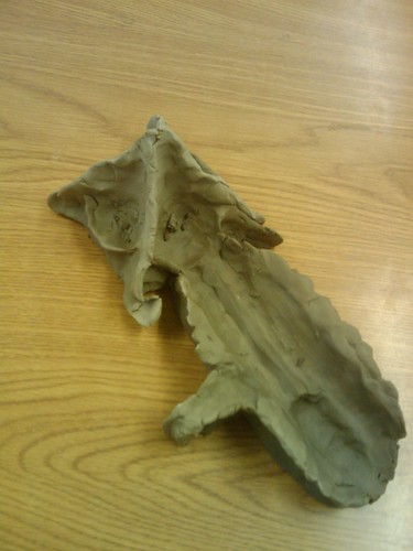
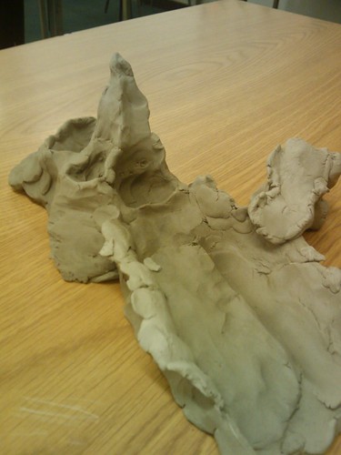
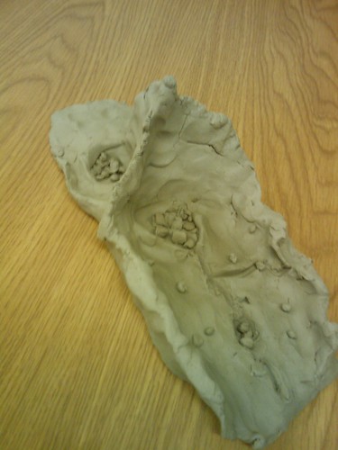
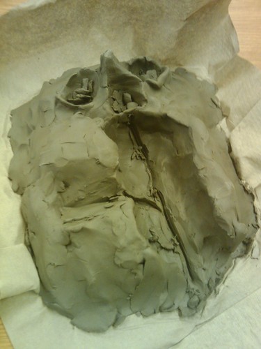
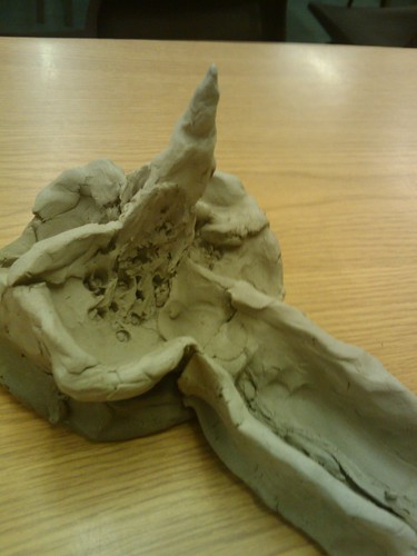
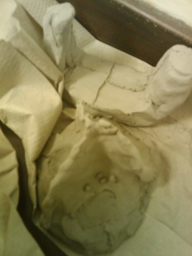
Secondly, we also spent a bit of time clay modelling. One class tried claymation, using stop frame animation, but I've still not managed to get these downloaded from the school cameras. I found this quite hard to do for a large class as battery failure became quite an issue, so with my other class, we simply modelled landscapes. The criteria I set was as follows- the models must show the following features clearly; corrie, arete, pyramidal peak, hanging valley, u-shaped valley, truncated spur, ribbon lake, misfit stream. The features must be in the order you would find them in the landscape e.g. by altitude. Students could add other features such as scree and tarns, but I basically wanted to see how good their feature recognition was. Some of the results are below. I haven't managed to load all of the pictures from my phone yet, so this is only a sample:

clay1

clay2

clay3

clay4

clay5

clay6

Bottom one is in two parts. Now for tomorrow's work...

Sunday, November 07, 2010

A cache, a code and a crowd to place it


Categories: s1 and s2, Other, Geography General

This is an idea, or bits of ideas I've had floating around my head lately. Will probably refine it as I develop it, but here's the bones of it anyway. I have recently been sucked into the world of geocaching, which, if my profession is taken into account, shouldn't really be that surprising. I love the adventure involved in visiting places that are either new to me, or are so familiar that I have never given them more than a cursory glance. I would say it's given me a totally different view of my own local area in a very short time.
I also have a long standing interest in developing literacy in my students. I have always been a reader and an admirer of the power of the written word, but my understanding of literacy has been turned on its head in the last year and a half, mainly through my involvement in the Scottish Survey of Literacy and Numeracy (SSLN). An expression of literacy skills can mean so much more than writing a story (although I can't hide my pride in students when they produce work like this).
Finally, I've blogged recently about QR codes and am very intrigued in the ability to hide a lot of information in a small square of paper. So, how does this all link together? Well, here's the idea...
I've been thinking a lot about personal/local geographies lately. I work in Troon and am not local to that area. I hear people in my classes talking about places and have no clue where or what they are. This became more apparent to me as we collated a map of Troon/School stories for our 75th anniversary open day on Friday (this is still being added to and some parts have yet to be updated by students, although I've temporarily locked the edits). I realise that there is so much more to a place than meets the eye. It got me wondering what parts of Troon students would like people to see in their town that they otherwise might not. Everyone knows about the golf, the beach, the harbour etc, but what is 'hidden' from the average visitor? For this end, I'm going to ask a couple of classes in the next couple of weeks for their 'vote' and why as a blog comment. This will mean there's a collective response which might also spark some discussion. This is going somewhere...
Today, I purchased a load of geocaching goodies, including containers. Most of these are for use within easy reach of home (as the owner, I'll also be responsible for their maintenance). However, I'm planning on putting one, with permission, at the most popular 'hidden' location. If you like, I'm crowd sourcing my geocache. I won't tell students it's exact location, but I'm planning on sticking a little QR code inside the cache, so that whoever finds it will also see the blog responses of the students, leading to potentially exploring some of the other suggestions - an alternative Troon tourist route. We could even do this as a map with the comments in the pins.
There are some factors to consider. Although it would be nice to have students names beside the comment, this is very open and the cache could be found by anyone, so I will probably just use initials to satisfy my urge as the teacher to know who's done the homework :-) I'll also be asking students to think carefully about both the comments (digital etiqutte etc) and also the location. Managing risk here is at the forefront of my thoughts and I would want to place the cache in a safe environment, especially if students were looking for it themselves. I do think it gives an opportunity for the words and work of students to gain an audience other than the classroom teacher. I would hope that this would have an impact on what and how students write. I also think that the people who find the cache couldn't get a better tour guide. The kind of places I'm finding while geocaching near home are the kind I would have known inside out when I was a kid. Part of us forgets about the experiences that await us right on our doorstep as life and work take over. If it takes a semi-geeky game to remind us, then we're all the better for it.

Thursday, November 04, 2010

Acrostic Poems

Categories: s1 and s2, Writing asnd assessment
Should have done these as Haikus instead, but might have taken a bit longer to explain. An end of topic summary by a couple of students on the Tokyo/Japan topic.

Japan's capital city is Tokyo
Agriculture in Japan includes rice fields and sugar beet
Population of Japan is around 127 million
Acid rain, earthquakes, volcano eruptions and typhoons are common natural distasters
Not uncommon to eat rice with every meal!

Rachel 2C

Technology at its best
Observe the gadgets for you to test
Keep them coming, I would say
You will never get bored down Tokyo way
Open your mind and open your wallet, that's what my mum and dad would call it!

Adam 2C

Wednesday, November 03, 2010

Story of a Glacier lost (Part 2)

Categories: Glaciation

Harry's story (edited down a little in terms of size, content all Harry's)

The story begins high up. Very high. So high that even snow does not melt. So high that the snow becomes thicker, turning gradually to ice. This is how Glacier was born and this is where the story begins.
Glacier was an old-school bully, sticking on to rocks and freezing, before moving again, taking the poor rocks with him. He used these to attack and erode the landscape around him. His story changed when he became entwined with Corrie.
Glacier was born in a shallow hollow, which would grow to become Corrie. He originally played nice guy with Corrie and got underneath her skin, quite literally. Glacier struggled, however, to change his ways and was once again the bully, cutting away corrie's backwall and deepening her floor. He got in between her cracks, freezing and then brutally pulling her rocks apart. The rocks he pulled were now being used to attack corrie's floor. Over time, however, Corrie realised that, despite this, Glacier was changing her for the better. She had grown from a shallow hollowto a deep and fine armchair shaped hollow. Then one day, without warning, Glacier left.
He slid off under his huge weight downhill, helped by gravity. Each was as upset as the other, their friendship now dead. Glacier had moved on, though, and was back to his old bullying ways, attacking the valley below them. Glacier had left only a rock lip and a lochan. Some helpless rocks lay strewn across the ground, these once strong and sturdy rocks reduced to scree. A friendship that was meant to last forever, now, forever, gone.

The Vicky Lake Show...

Categories: Glaciation

Sharing a story written by one of my students to show the work of ice in an unusual way:

"Hello, and welcome to the Vicky Lake show. First up we have Christopher Corrie and Glenda Glacier, who have been going through a messy divorce while fighting over custody of their children, Rocky and Pebbles."
"Here we go again, always the same old story", thought Vicky to herself apprehensively, "Divorce, custody, arguments..."
"Now let's welcome Christopher and Glenda to the stage" she told her audience.
It appeared that Christopher Corrie was heartbroken. Glenda was leaving him and taking their children with her. She had been the love of his life, shaping his life so much that he would never be the same again.
" Now, Christopher, I want you to tell me how you and Glenda met" Vicky asked eagerly.
"Well", he started, "it was a while ago. Too long ago for me to remember, actually. As I recall it, we met one very cold, long winter. I was covered in snow. Next thing I remember, Glenda and I were together and I was the happiest I had ever been. She impacted on my life so much that I had to give up a lot to be with her. She changed, She started plucking parts of my life that I got so stressed and worn. I Think that's why she moved"
"That's not what happened!" Glenda disagreed.
"Well, Glenda, tell us what happened then" ventured Vicky
"OK, well, my life has been dynamic as I'm forever moving. I was created during the ice age when snow just kept falling, so much so that the snow underneath truned to ice. I have been moving all my life. It's not my fault, it's gravity!"
"OK, but what about the impact your behaviour has had on Christopher?" asked the host.
" Well, as I said, gravity is to blame. It is forever moving me downhill, so I have no choice but to grab on to what I can. Unfortunately, the pull is so strong that I fell I've ripped off parts of Corrie" Glenda explained emotionally.
" I couldn't helped being pulled toward Christopher. And as for me 'plucking' parts of his life, I can't help that I'm so cold, everything freezes onto me and gets broken apart"
" You left me an empty hollow, Glenda", Christopher added desperately.
Glenda just turned away from him as she knew she would get upset if she looked at him. Vicky was bewildered. She had never met such an interesting couple in all of the programmes she had presented.
" And what about the children-Pebbles and Rocky?" she asked nervously, waiting on the next argument.
"Well, I think I should keep them, as I will keep them in one place and not move them around all the time" stated Christopher.
"I think it's right that I should have them, because with me, they'll always have their mother and other friends as I travel. With him, they'll have one parent and that's all".
"Well, I hope you both sort this out and I wish you both the best" whispered Vicky in heartfelt tones.

2 months later: "You may remember Christopher Corrie and Glenda Glacier from 2 months ago? Well I recently heard that they broke up permanently and Glenda kept the children. Now on to our next couple, Wendy Waterfall and Gregory Gorge..."

I thought this was absolutely brilliant, accurate in the content (I edited a mistake in one small part, but the words are those of the student) and presented in a very creative and unfamiliar context. Well done, Elle!

Monday, November 01, 2010

Writing the earth. Or copying Alan...


Categories: s1 and s2, Glaciation

The blog's been a bit quiet of late, but the classroom work has been going like a fair. Much of what I'm doing in class just now is either as a direct result of new ideas gained or old ones regained from my attendance at the SAGT conference. I attended a brilliant keynote speech by Alastair Humphreys, which showed why he is often invited to schools as a motivational speaker. Alastair has made the impossible possible through his attitude to challenges, such as cycling round the world in four years on £7000, circumnavigating the M25 on foot whilst relying entirely on the goodwill of strangers and is currently preparing to emulate Scott's Antarctic journey, as he puts it, "without the death part"! I'm mentioning this not just because of the fact I enjoyed his talk immensely, but also because, through his website, there are some excellent accounts of his journeys which could easily be adapted for classroom use. I am particularly drawn to a Scottish example which is rich in geographical terminology and would be excellent for use with a class learning about Scotland, weather, rivers etc

The two seminars I attended were by Noel Jenkins and Alan Parkinson, and both made a big play of the role Geography has in developing literacy, a particular area of interest to me. I'm going to share some work over the next week or so which shows the results of some of the things we've tried since, but here's a brief summary:

1) Telling a story around a geographical process - Alan had used the example of 'river as a person' , telling his life story from youth (upper course) to old age ( lower course). This came too late for use with my S3, but I decided to try something similar with Glaciation. When I mentioned this on twitter, Tony Cassidy sent me an excellent example of the story of a Hanging Valley, as told through 'Their Song;' and old show that used to be on the radio sharing sad stories. I introduced a similar idea to my S3 classes (see last post). This was really not easy, as the class couldn't equate the telling of a story with the explanation of a geographical process. For me, the link is explicit. For instance, the story of a corrie's formation has a start, middle and end, there are relationships between the ice and the landscape which are made and broken and the story of both changes as a result of this. I am pleased to say that some of the work I've been looking at this morning shows the promise of being absolutely first class. One story portrays the glacier as a bully, with a total disregard for those around him. Another is being rewritten as a Jeremy Kyle chat show, where the glacier and the corrie are fighting over the custody of the children (scree). Suddenly, these features are personalised and from initial scepticism, I feel as though a fair number of the class are embracing the idea of presenting their knowledge in an unusual way. This for me is key. It demonstrates firstly whether the knowledge is sound and, secondly, whether the real understanding is there should the students be asked to demonstrate it in an unfamiliar way ( a trickily worded exam question?). My NQT is doing something similar for Hurricane Katrina with an S1 class.More to come on this.

2) What if they had a facebook profile? Last year, I was looking at change in rural France (as exciting as it sounds) with an S4 class. We managed to make the topic engaging by having a twitter conversation with a 'Farmer', followed by a facebook/bebo/myspace mock profile for typical residents of rural villages. I was looking back through these today and some are fantastic. Alan had mentioned the template that Tony provided at SAGT, and this morning I had a class who were looking at rural Japan, so we are recycling this exercise using it. This is a really good way to summarise key points, information etc, but is much, much harder than it looks at first glance. I get these back in a week, so I'll try to share some here.

3) QR codes - Noel had a really fascinating seminar which was essentially based around his hobby of urban exploring. There are a number of ideas he shared which would have been of use for the Industry topic I've just finished with S4, for example, telling the story of a building unloved could be a great way to recap on Industrial change, and rebranding a building could be similar in terms of showing an understanding of urban and industrial change. However, he talked about personal geographies and I was reminded of this great post (which I think Alan also mentioned). I had previously asked my S4 to do a five minute walk detailing their response to the urban environment as homework. Much of what was returned wasn't place specific. I'd wondered about what to do with it, as I didn't just want to give it back and for it to disappear, so it would be nice if the authors could 'hide' their personal response to a landscape through these codes. It provides an audience for student work, but also requires a bit of unscrambling. I think this is something I'd definitely like to try with younger classes looking at local geography.
Overall, another really excellent piece of teacher CPD which, as always, will influence my own practice. Thanks to those mentioned here for the great food for thought they have provided.