<body><script type="text/javascript"> function setAttributeOnload(object, attribute, val) { if(window.addEventListener) { window.addEventListener('load', function(){ object[attribute] = val; }, false); } else { window.attachEvent('onload', function(){ object[attribute] = val; }); } } </script> <div id="navbar-iframe-container"></div> <script type="text/javascript" src="https://apis.google.com/js/platform.js"></script> <script type="text/javascript"> gapi.load("gapi.iframes:gapi.iframes.style.bubble", function() { if (gapi.iframes && gapi.iframes.getContext) { gapi.iframes.getContext().openChild({ url: 'https://www.blogger.com/navbar.g?targetBlogID\x3d23069377\x26blogName\x3dOdblog\x26publishMode\x3dPUBLISH_MODE_BLOGSPOT\x26navbarType\x3dBLUE\x26layoutType\x3dCLASSIC\x26searchRoot\x3dhttps://geodonn.blogspot.com/search\x26blogLocale\x3den_GB\x26v\x3d2\x26homepageUrl\x3dhttp://geodonn.blogspot.com/\x26vt\x3d8160912104340948054', where: document.getElementById("navbar-iframe-container"), id: "navbar-iframe" }); } }); </script>

Odblog

A weblog designed to share Geography resources with students and colleagues

Tuesday, October 31, 2006

Balancing Act


Categories: Rivers, Limestone
Enjoyed today. The Biscuit game, I felt, went very well. The pupils feedback was good, and they seemed to enjoy the interaction, or maybe it was just the toffipops. Nice limestone and acid experiment to replicate chemical weathering with Miss Green's class. Back to the serious business today, with a Higher supported study on my mind. The traffic lighting exercise suggests the following areas being of most concern:-
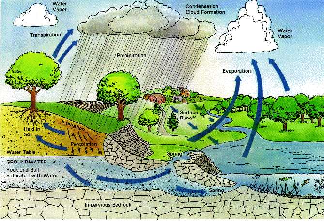
1) Explain how a balance is maintained within the hydrological cycle. I feel perhaps on reflection that I have confused you a little with this topic as we spoke about soil water holding capacity in a separate lesson from the hydrological cycle, but the two are very closely related, and we should still be talking about inputs, outputs and storage. I have put up this link, which may be of some help.
2) Construct and analyse river hydrographs to show the relationship between rainfall and river flow. We have actually spent quite a bit of time on hydrographs, and the work in class seems to suggest a decent understanding, so perhaps this is purely a confidence thing from an unfamiliar topic (not covered at Intermediate). I am therefore going to get students to construct a hydrograph from data and then label, describe and explain.
3) GMT involving cross sections. Same again with this, we seem to have it in class, but I will present a meander like the one below, and after discussion we will attempt a labelled cross section

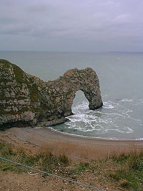
4) Upland Carboniferous limestone features
5) Sketch map/cross section of a carboniferous limestone landscape
Most of the pupils in the class have been doing these since s3, and have actually used these type of resources before, but I'll definitely use some kind of sketch to annotate here ( although I'll probably need to do one myself tomorrow)
Other resources which I would like to use are the board for Question of Rivers by Val Vannet, to break the hour up, but particularly for the map slides on this, as well as having a nice meander playing through a loop from Dan raven Ellison's footage. Past Paper activity tied in to both Hydrographs and Limestone.

Monday, October 30, 2006

Rich Tea, Anyone?....


Categories: Development and Health, Writing and Assessment, Geography General, Limestone, Coasts, s1 and s2
Just spent a fortune at ASDA on biscuits for a game tomorrow with my s4, although forgot the Ryvita...might do some kind of lesson feedback exercise with this using another Ollie Bray idea. Lots of really good discussion arising from the LEDC or not exercise, a good preparation for what we are about to do tomorrow. Supported study is starting this week (Wednesday), and with the Higher NAB in mind, I am going to trot out the traffic lighting exercise again, just using the arrangements, hopefully allowing me to focus our session around your needs. Sitting in on Miss Green's class with s3 today, she is planning to do a little experiment with Limestone-intrigued to see this in action, as it's something I've never tried with a class. The conundrum activity worked well with my own s3 as a period starter today, and I see another couple of comments have appeared on your blog, well done. I will leave some work for s3 to continue on the coasts topic while I observe next door's sciencefest. s1 are doing the assessment today. Have marked one class and the results are very encouraging. Just one thing from today's classes to update. I was telling my s2 about the possibilities of inter school chat with Japanese schools through www.japanuklive.org.uk and will keep you posted here re: the outcomes.

Sunday, October 29, 2006

Coastal Conundrums, biscuits for later...

Categories: Coasts, Rivers, Urban, Development and Health, s1 and s2
Busy weekend! Just back from a conference, lots of great ideas, some of which I'll use in the next few weeks. One thing which was mentioned, and that I have already played around with, is Live Local, a little like google earth, but not perhaps as user friendly. The one advantage that it has is the level of detail that can be shown close up. I would like to use this as a preamble to some Higher rivers work on the Brighton map, so I am hoping that this link works. Might also try to use it to find some meander scrolls etc, and also the knick point on the Clyde to show students. I also liked the idea from Ollie_Bray concerning the use of Sim City as homework. Thought about using this with s2, who are just finishing Japanese Cities. s4 are ready to start Development and Health after a bit of feedback on the NAB, and I will start this off with my own well-used LEDC or not exercise, but I hope you like biscuits...details to come in the next few days! s3 are just about ready to move on to Coastal Land Uses, but I think some Conundrums might come in handy (from Rob Chambers' Geobytes ) as well as a little check on how well students understand the Physical geography of coasts by using the photos here. Which leaves poor s1 with their assessment...although I have every faith in you all! Just bought a webcam, and when I can get the thing to work, may start experimenting a little with the camera. Last few words, I am really very pleased with the s3 response so far to the blog online homework, although their older Higher counterparts are more than a little slower off the mark. This is a great way to collaborate, and a nice break from the normal and formal type of homework, so let's have a go at making full use of this.

Thursday, October 26, 2006

Student Rivers Vid

Watch the video
Categories: Rivers
Just a little exercise we have been messing around with in class. Will ask for alternative accounts and additional info. I am posting the video to the student blog, so that you can comment on anything which you feel could be added or changed, but I am pleased with this as a first student video on the blog. Hydrographs and River features past paper homework to supplement. Will also try to do a bit of mapping tomorrow. s1 are still mapping Brazil-got a little less done today than planned, but such is life...

Wednesday, October 25, 2006

Bookmarks for Higher

Categories: Riv ers, Rural Land resources, Geography General, Coasts, s1 and s2
Rivers work today with Higher went quite well, thought I had saved the screens to my pen drive, but must have been to school laptop, so will retrieve. Have found a couple of excellent resources for Higher, both for current topic of hydrosphere, and for the course as a whole . The first, for use tomorrow, has some great video footage and tasks here . The author of these resources, Tom Biebrach, has created several excellent resources, some for use with Google Earth like the one here. If you have internet access, and you don’t have this application yet, I really advise you to download it here . The second resource is Val Vannet’s blog which is specific to the Scottish Higher, and has a recent post on Rural Land Resources which will be of use for a topic we have only recently finished. .
Assessment features heavily tomorrow, with s4 taking the Human Environments NAB, and s1 having a little bit of prep for Monday/Tuesday before getting back to Brazil. S2 are working on the assessed Tokyo Report, and I must thank Chris and Stephanie for their help in the student tutoring which has allowed us to take advantage of the ICT facilities during class time in small groups. S3 enjoyed terrorising my whiteboard with some of the Coasts games at Geobytes , so several people will be no doubt wanting their turn tomorrow (but only after spit formation diagram!). The first comment has been made on the student blog and I see the wiki has also had an entry for Glaciation. Glad to see you making use of your own spaces, let’s keep it going.

Tuesday, October 24, 2006

Get posting...

Categories: Rivers, Glaciation, s1 and s2, Geography General
I constantly realise that computers are much simpler than I think. We had a problem posting comments to the student blog because you were required to have a profile. I thought I would have to transfer the post to a wordpress blog that I have been messing around with in order for students to post comments, but it literally took me 5 seconds to change the post settings on the original blog. Anyway, the upshot is, s3 can now do the online homework task without any hassles, so please post away! Not much happening tomorrow, hoping to do a bit of work on a presentation I've to do, but have a powerpoint for higher, which basically throws together a few of the themes that we have been working on re: rivers (sample slide above). I am hoping to use these slides not just to answer the simple questions posed on them, but to reason our responses. I will do a bit at the whiteboard, and try to post up the results, but may also involve students in some audio activity, as well as letting some loose on my short rivers video. Its half and half ICT room/classroom for s2 tomorrow for the Tokyo research, providing Chris is in to help out, after which this becomes your homework task. See that s4 have finally started using the wiki , remember to come and ask for help before the Thursday NAB if you have any concerns

Monday, October 23, 2006

NAB links and others

Categories: Population, Urban, Rural, Industry, Coasts, Rivers
Lots of links for s4 today for Thursday's NAB assessment. First stop is the BBC Scotland 14+ Population website, along with the Bitesize site for Standard grade and Higher. Not all of this will be useful to you, but I'll give some pointers in class tomorrow. Same can be said of the Scalloway site, which has lots of great resources, but is designed for Standard Grade rather than Intermediate, so we'll have to pick out the relevant sections. There are some bitesize movie clips for Population etc on the Millfield site which might be useful, and a Population and Farming guess the terminology from www.radicalgeography.co.uk , which might come in handy, but can also be adapted for our syllabus. Other useful sites include the revision guide at www.geographypages.co.uk . Don't forget the wiki.
For Coasts with s3, I was browsing the Geobytes website, which has loads of coasts material, including podcasts and games, which I will introduce to the class tomorrow. Higher are really just getting started again on river features after we covered processes of erosion, transportation etc today, so didn't really get the chance to dabble with movie maker, so will use this throughout the rest of the week. s1 all starting Brazil today, brainstorming exercise, then some mapping. Brazil is NOT in Europe, incidentally....

Sunday, October 22, 2006

Student Blog Activity


Categories: Glaciation, Rivers, Geography General
Hope you have all had a good rest during the break. I would like to say that I have, but DIY dominated mine, I'm afraid. Did manage to get away for a couple of days, and came up with an activity based on a photo I took and some other sources. I have put this over at the student blog and have asked you to use the comment option to complete the task. I think you may need your own profile for this, but we'll talk about that tomorrow.
I would like to use some old resources with Higher tomorrow, basically a couple of video clips which I will run through Movie Maker. I hope to use this to ask students to comment on possible impacts of drainage basins on hydrograph shapes, as well as introducing some of the topic work for river processes, features etc. A reminder that you can revise this yourself on Bitesize. I was surprised but also very pleased by some of the feedback from the student surveys. Main things that came out of this were that students liked the Interactive activities, liked being involved at the whiteboard and Lithosphere seemed to be the favourite part of the course because of the links to previous work. Some pupils were finding the changes in the marking difficult to adjust to, and felt that they needed a little more guidance before completing past paper homework. I will try to do some kind of summary of the results which I can put on one of the blogs.
s4 are practising past paper questions for the NAB, and s3 are progressing into Coasts with a short video. s2 will be discussing how to approach the Tokyo report, before researching this for themselves. With s1, I really want to wrap up the work on hurricanes, so that we can move on to Brazil this week. Cue some favela building...

Wednesday, October 11, 2006

How are we doing?


Categories: Geography General, Rivers, Coasts, Rural, s1 and s2
In many respects, tomorrow's lessons will hopefully illuminate us in a few cases as to the above question. I realised today that we are three months into the Higher course, and I want to see what the general experience of students has been so far in terms of how they are coping, what they find difficult, easy, interesting, boring etc and how we can improve on this. Last years Higher set responded extremely well to a lot of interactive approaches, but the dynamic feels very different this year, and I am hoping the feedback will help me direct my teaching to this groups' strengths. I have made up a small questionnaire, and am quite willing to use up a period if its beneficial. However, we will probably get onto some Hydrograph reminders and rivers. For s4, how are we doing comes in a different guise, as we continue to work on the rural movie as a revision tool, but I would like to make this a pacier activity, so will probably give pairs working on this a more particular focus and stricter time controls so as to involve everyone. s3 are going to see a couple of my favourite locations-Happisburgh (family holidays when I was younger) and Morar(see above-can't think of many better coastal settings in Scotland), but these will only be partially revealed, and at specific times in the period. My Happisburgh pics are going to be used to supplement a Holbeck Hall type activity (have seen this on a few sites) as a starter for coasts. s2 are Lost in Translation today-we changed the order of this activity in the work scheme to coincide with the Tokyo Report exercise, and s1 are finishing the Hurricane video-might use some Violent Earth clips too.

Tuesday, October 10, 2006

Stations

Categories: Rivers
Thinking of how to break up double Higher tomorrow and I am going to use some 'stations' in period 6. I have tried to vary the activities and put in some thinking skills, visual tasks and extended writing. We never quite got round to Hydrographs, so I will need period 5 to prep this, after which, a variation of this living graph exercise will be used at one station. Other things definitely being used- the odd one out exercise from the same batch of resources, some terminology cards descriptions, and another hydrograph exercise. I have also put together a resource based around Google Earth for looking at drainage basins and watersheds, stream hydrographs and a bit more, where students can use the whiteboard, and finally, a written exercise based around what we have learned so far in the Hydrosphere unit. There was also a nice activity at Paul Williams blog for A level students, but don't know whether I will use this yet with my class. Not much else happening for tomorrow, s2 onto Japanese cities as mentioned before. I started my movie activity with s4 today and had to question the relevance of 'Don't believe the Hype' by Public Enemy being on a Rural Geog video. CAP? s1 very enthusiastic about Hurricanes, lots having been to Florida, others wanting to know about the 'hurricane' which we caught the tail end of, and others wanting to know about Tornados etc and the differences. Some even knew about the Willy-willies!

Monday, October 09, 2006

Hydrographs, Hurricanes, Hay Bales and free calls...

New Orleans after Katrina
Categories: Rivers, Rural, s1 and s2, Environmental Hazards, Geography General
Following on from yesterday's post, I have created a storyboard for s4 to work on for their rural revsion movie. Had to limit it to the EMDC case study, as I felt that this alone might take a couple of periods. Will try it out tomorrow. have given the option of audio commentary and/or slide text. Higher are following on from the work we did on drainage basins yesterday. We had some good screenshots from the whiteboard, which I have miraculously managed to wipe, so I will try to recreate these, but using the GE image and then the map worked quite well for identifying the drainage basins and their watersheds. I was very pleased with the results of the brainstorming exercise on factors influencing channel flow using the Glen Croe slide, so I will again try to recreate this. We will take more of a look at the shape of drainage basins etc tomorrow, but will probably get on to Hydrographs. This is an area where some classes have previously struggled with the description element, so I am going to start, after a general introduction with this living graph from Russel Tarr, and will then put up a couple of hydrographs on the whiteboard with statements to drag to the appropriate graph. I had planned to give s3 a movie type activity, but after a restless period today, I feel a more calming activity would be beneficial! A little bit of field sketching perhaps...s1 are ready to move on to extreme waether and we will probably have a look at some New Orleans before and after pictures before using the New orleans video, which ironically forecast the disaster two years before it happened. Been experimenting with skype , which I think would be good for inter school links (free internet calls), but haven't quite worked out exactly how or who could use it yet.

Sunday, October 08, 2006

Drainage Basins on the IWB

Categories: Rivers, Limestone, s1 and s2, Geography General
I am doing drainage basins with my Higher class at the moment. Google Earth is being really temperamental since I temporarily lost my profile on the laptop, and there appears to be no real reason for this according to the technicians, so I am just hoping that this placemark is not surrounded by patches of blue seas like the last few that I have tried. I am going to use this with images put on a powerpoint, where students will be encouraged to first of all mark drainage basins on GE and the photos, as well as O.S. maps. We will then use the image of Glen Croe to brainstorm factors affecting channel flow. I fancy trying two of the ideas mentioned on http://www.digitalgeography.co.uk today in future lessons, but with moviemaker, rather than photostory. I think that the 'What happens next?' is something that I could use (thinking about a coasts movie here), but I am also very keen on the student commentaries on a set of images in movie maker. I can perhaps do this tomorrow with s3, but with time as it is, will probably do the National Parks 6x6 from Tony Cassidy mentioned a few posts ago. Again, taking inspiration from here, s2 will be using the Lost in Translation exercise found at the RepresentingGeography section. Need to go over the Weather Investigation with s1, but might get started on extreme weather. s4 are now ready to tackle the India rural case study after the excellent responses to the images of LEDC/MEDC rural activities (see the student blog soon).

Tuesday, October 03, 2006

Evaporation, Population and a bit more..


Categories: Rivers, s1 and s2, Population
Have been looking out some resources to start the Hydrosphere topic with Higher. My intentions are to use a mapping from memory activity for the water cycle as a period starter, but there are some excellent resources for this whole topic online. For tomorrow's work, there is a good video of the water cycle, as well as some more useful resources on the NASA site. If we manage to get ICT booked (hopefully this time when pupil access is not restricted!), I would like to use this site, which is pretty thorough and probably pitched at around the right level. My s2 tomorrow are looking at population in Japan. We will be doing a little work on population pyramids and linking a thinking skills living graph activity into this that I have put into the Pupil Booklet. I might use classtools and the lights out to talk through the pyramid structure, and there are some links at Rich Allaway's site for use with classtools here , which can also be used with my s4 for revision soon. Unlike today's lesson, I will try to keep to the Geography and away from the Elephant Polo (long story)....

Monday, October 02, 2006

Out in the country


Categories: Rural, Rural Land Resources, Limestone, s1 and s2, Urban
I remember this time last year thinking that every lesson I taught had some bit relating to farms, and I find myself here again, so much so that I took a break from it to create this revision tour for the Intermediate Urban Case study of Paris. If you use this in conjunction with your audio powerpoints, it should help with the assessment revision. I've tried to pose questions within the information to direct your studying. Back to the countryside. I am doing set aside(see photo) and quotas with Higher, but after this, I intend to get students to pick a number between 1 and 7, and split up the key points for rural land resources. I think we will then create summary sheets for a partner, who may then edit. s4 will hopefully be almost finished looking at rural change in an MEDC, so I want to use a couple of images stuck together in a split screen to highlight the differences in rural landscapes between MEDC and LEDC. Some discussion on this, maybe annotate the pictures and put them on the student blog with the higher work from today (left it on the PC at school). s3 are looking at land uses and conflicts in a limestone area, used the 'Who killed Jeremy?' exercise today, and will get some feedback at the start of the period. My s1 today really surprised me-a) they got very animated about leaving class for 5 minutes to get the weather readings, and b) they were very enthusiastic about recording their own weather forecasts. I'm not complaining, pleased that they have taken to this, and have managed to secure some PC's for tomorrow to get more people forecasting.

Sunday, October 01, 2006

Going to Tokyo


I have worked out (probably wrongly) that period 1 tomorrow with my s2 will be round about rush hour in Tokyo. We will be looking at Population in Japan and Japanese Cities this week, so I thought we could drop in on Shibuya (pic opposite) and some other Tokyo webcams to sample the Tokyo buzz. I might use google earth around Tokyo and the Kanto Plain to help us start the topic. s1 are finishing recording their weather forecasts with the aid of the forecast board, and if it has survived a gust of wind at the weekend, we will visit our all new weather station to start our weather projects. s3 did a good activity using www.classtools.net to brainstorm on images, and we will continue working on land use conflict management today with a murder mystery from the sln site, all the links here . We will pick out the issues at the end of the activity. s4, still on our Paris Basin Case study, but with the NAB on the horizon, and the wiki now up and running, I thought I would put up some population links, which we will be able to use again when we start the development topic. Last, but by no means least, Higher are doing our Dorset Case Study, and while we get on with this, I will put up some images on the board for student use and labelling-looking for features, land uses, conflicts and solutions to be id'd just from the pictures. I will print the screen and stick them on the display of work blog. Light relief for Monday, some tricky questions here. No atlases allowed.

Teachery stuff...

Categories: Geography General
I have been doing a bit of research on people's different learning styles. I use the whiteboard a lot for images in class, but have been trying to bring in audio and kinaesthetic (moving about!) approaches to cater for people who learn better in this way. If you want to find out what kind of learner you are, try this test . Apparently, I am music and nature smart, but not very logical. I am sure there will be some who agree with the last part of that. Try for yourself.