<body><script type="text/javascript"> function setAttributeOnload(object, attribute, val) { if(window.addEventListener) { window.addEventListener('load', function(){ object[attribute] = val; }, false); } else { window.attachEvent('onload', function(){ object[attribute] = val; }); } } </script> <div id="navbar-iframe-container"></div> <script type="text/javascript" src="https://apis.google.com/js/platform.js"></script> <script type="text/javascript"> gapi.load("gapi.iframes:gapi.iframes.style.bubble", function() { if (gapi.iframes && gapi.iframes.getContext) { gapi.iframes.getContext().openChild({ url: 'https://www.blogger.com/navbar.g?targetBlogID\x3d23069377\x26blogName\x3dOdblog\x26publishMode\x3dPUBLISH_MODE_BLOGSPOT\x26navbarType\x3dBLUE\x26layoutType\x3dCLASSIC\x26searchRoot\x3dhttps://geodonn.blogspot.com/search\x26blogLocale\x3den_GB\x26v\x3d2\x26homepageUrl\x3dhttp://geodonn.blogspot.com/\x26vt\x3d8160912104340948054', where: document.getElementById("navbar-iframe-container"), id: "navbar-iframe" }); } }); </script>

Odblog

A weblog designed to share Geography resources with students and colleagues

Sunday, April 23, 2006

Mumbai misery

Categories: Urban , s1 and s2 , writing and assessment, Other
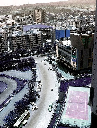
I have been trying to copy my Mumbai tour on Google Earth to ourmedia, and although I have managed to save the tour, the images come up as big blue X's.This is it as we see it at present, I'll try to find a way round this-the important things are all still there, the placemarks, the summaries etc. Why not copy the file and save your own images for this? In the meantime, a nice image of Mumbai from Flickr . OK, tomorrow(today?)-s1 will be continuing their work on settlement. I think we will do a map from memory, and an image or two set up on the whiteboard with a microphone to get us started. Maybe a good time to use the Glasgow Google Earth tour I have. s2-Will have some Brazilian music as background as we start the topic with a brainstorming session-time runs out when the music stops. We might put a short slide show together of the results. Then a little work with some images, and an activity from the 'Places' textbook-although not forgetting we still have some movies to see. s3 will refer back to our Mumbai introduction, a little textbook work, while a class assessment task will be ongoing using the whiteboard. I think there is a lot of scope for some of Monday's work to be showcased here, so finger's crossed (I have been saying this for a while). S5/6 will be doing revision stations, and one will involve use of the wiki , which I see has its first entry-remember it is for you to use and change, please take advantage of the resource you have.

Summary posting:First week back...


Categories: s1 and s2 , population, urban, development and health, other
Not been posting for a while, just settling back in after the holidays-just a couple of thoughts to share. I used a google earth tour with s3 some time ago, and it is now being hosted by Tony Cassidy of Radical Geography here , many thanks. May be of interest for revision purposes, or just of general interest as the World Cup approaches. The areas that were poorly defined have now been updated, I would imagine with the increase in interest the WC will generate in mind. s1 finally began the settlement unit, and s2 have been showing some Tokyo movies and powerpoints. s3 have started the Mumbai case study (see more in next post), and s4/s5 /s6 are now revising with the exams in mind, the last assessment being the Human Environments one for Higher on Friday. s4 did some stations work on Friday which I will adapt to Higher level on Monday. That's about it. The photo is the Allianz arena, visited on the Google Earth tour(still under construction on GE)

Tuesday, April 18, 2006

More Google Maps and Google Earth


Another good practical application for google maps-I have been reading a new blog by Noel Jenkins, the author of juicygeography and digitalgeography who is doing some amazing things with mobile phones and their relevance for fieldwork. I can't even begin to keep up, being a non-mobile user, but some of the maps, and software etc that he is using are interesting for me, and I am sure that some of the mobile applications, even outwith a classroom setting may be interesting for some of you who are up to speed with mobile phone technology. I have tried creating a map of some higher urban field work using www.communitywalk.com , particularly useful for revision purposes with the assessment coming up. It details all of the locations within Glasgow that we visited, and their relevance for your urban study along with some photos of locations. Unfortunately, I had problems linking this to the blog, and found the site to be very slow, so try this link. You can also create a KML file, which opens in Google Earth. Here's mine if you have GE at home.
I think the map works best when, like Google Earth, you focus in on each location. Regarding the mobile applications, this is something I would really like to give some thought to for the s3 Alps trip-It would be good if we could set up a blog and post directly from the field to this.
I have also set up an Intermediate wiki for assessment writing and have changed the password on the Higher one. See me about the new password.

Sunday, April 16, 2006

Google Maps

Categories: Glaciation, Coasts, Rivers, s1 and s2, Other

I have been looking at uses of Google maps, primarily through a great blog, http://googlemapsmania.blogspot.com . This led me to a site called wayfaring which lets you create your own maps and add photos, videos, comments, links etc. I think that this has fantastic potential for use in class. I can see us using this with topics such as Japan in s2 for example-create a map at the start of the unit, and add waypoints as we work through the topic. Students can add their own links, photos etc and can become really involved in the map-building process. The same data could be transferred to Google Earth to create tours, and so on. I also think its a good case study revision prompt-map Rural Land Resources locations for, say, the Cairngorms case study, add info points and anyone can access it. The tags also let you search for similar themes elsewhere that other users have created. Here is an example of a map I created when trying this out-It has relevance for Intermediate ( Glaciation, Rivers), and Higher (Lithosphere, Hydrosphere, Rural Land Resources):


If the map is not showing, the link for it is below:
http://www.wayfaring.com/maps/show/14225

p.s. I have added a Flickr badge on the sidebar which can link you to photos which I have used/may use in class. Not finished uploading all of these yet, just some Alps and Scotland landscapes.

Sunday, April 09, 2006

Easter School part 2-The ones that got away

River 2

Categories; Atmosphere, rivers, rural land resources, glaciation, limestone, coasts, urban, industry
Watch the video
I have several links which we will probably not get the opportunity to use, but which I think are extermely useful for our revision purposes. For coasts in particular, there are some great resources including podcasts on the geobytes website, a site which I have only recently started browsing and can highly reccomend to students-some first class revision materials here. I will put this in the links section when I get a chance. For coasts(lithosphere, rural land resources), sand dunes(biosphere) and footpath erosion (rural land resources) images, there is a geographyalltheway gallery, and Tom Brierach does a flash animation for coastal erosion, and a nice oxbow one too.
I have also been searching back through any of my own images which would be useful for revision-plenty on glaciation, rlr, some on limestone, some Glasgow urban photos etc. I am thinking about the best way for you to get access-might put them on Flickr or something similar and link it here.

Easter School Part 1-Materials

River 1

Categories; Atmosphere, Rivers, Lithosphere, Urban, Industry, Rural Land Resources, Development and Health
Watch the video
No rest for the wicked. I have two very basic videos here, taken with an old(ish) digital camera during a couple of days away recently. I will be using a worksheet that I have put together, which we may or may not have time to get through, but all the resources you need will eventually be posted on the blog. The worksheet is here . There is a link to a hydrograph exercise put together by Russel Tarr and Rich Allaway. I have also included links to a Thinking Skills exercise on river basins here.
Atmsophere links sourced by Paul Williams and posted on sln first can be found by clicking this. I will hopefully be able to use the whiteboard to get through a bit of circulation cells/wind patterns/ICTZ revision. I have created a statement sort for a model answer, with some red herrings thrown in.
For Urban revision, I have started off using a mind map from Freemind software-I may need to download this at school to show this. There is also a user friendly link for mind mapping any topic using http://www.neale-wade.cambs.sch.uk/revision/mindmapper.html.
I have followed the urban O.S. question with an Industry one which I have created myself, using the O.S. website get-a-map feature. This is in response to an area which was highlighted by your traffic lights exercise. Hopefully, it is of some use. I have also made up a quick dominoes activity-not posted due to problems with uploads just now.
Finally, I thought I would start the Environmental Interactions section with lifeswitch, found on Alan Parkinson's geographypages, which has some great country summary information relating to factor's influencing development. I have also linked to the latter site for a little exercise on NIC's.
All of the exam questions I have picked out are from pre-1999 papers, but you should a) recognise some of the questions if you have been using your own past papers!, and b) gain experience of some of the less frequently asked questions.