<body><script type="text/javascript"> function setAttributeOnload(object, attribute, val) { if(window.addEventListener) { window.addEventListener('load', function(){ object[attribute] = val; }, false); } else { window.attachEvent('onload', function(){ object[attribute] = val; }); } } </script> <div id="navbar-iframe-container"></div> <script type="text/javascript" src="https://apis.google.com/js/platform.js"></script> <script type="text/javascript"> gapi.load("gapi.iframes:gapi.iframes.style.bubble", function() { if (gapi.iframes && gapi.iframes.getContext) { gapi.iframes.getContext().openChild({ url: 'https://www.blogger.com/navbar/23069377?origin\x3dhttp://geodonn.blogspot.com', where: document.getElementById("navbar-iframe-container"), id: "navbar-iframe" }); } }); </script>

Odblog

A weblog designed to share Geography resources with students and colleagues

Wednesday, November 29, 2006

Hotel Rwanda

Categories: Population, Development and Health, Rivers, Environmental Hazards, s1 and s2
Really enjoyed the Higher class today, we managed to get a little bit of everything into the lesson. We had a little discussion about obstacles to migration and decided that conflict could be one of these obstacles, at which point I showed the Darfur game. Although my directionless running did raise a few laughs, I think that people got the message, and I have encouraged students to have a go at the game. After this, we started talking about the desperation that accompanies some migrations, and managed to show this , but couldn't find this . This line of discussion brought us onto forced migration, and the idea of migrants as refugees. I asked students to watch Hotel Rwanda, but take notes on 4 things-1) Push factors relating to any movement in the film 2) Type of migration -intra, international, long term, temporary, intra urban, rural to urban etc 3) Migrant profile-was this a typical migrant? Young, male etc and 4) Obstacles to the movements in the film. We started watching this in the second period of the double, and will continue tomorrow.
s2 started their image searches for the movies, but wish I had taken time to read Ollie Bray's tips on searching for images on the internet. have this class tomorrow, but don't know if I have the ICT room available. If not, I'll be looking at earthquakes, and may use some of the Violent Earth material. Soon be time to implement some Earthquake Drills , and I have also the intention to use a shaker table with class at some point.
s3 are right in the middle of the Rivers Challenge Board, Group 3 (Upper Coursers) are in a healthy lead at the moment, but still plenty of time to 'steal' some money back-we are only at the £300 question. After we finish, some thinking skills as a settler.
We are fairly moving through the Development and Health topic with s4, and I think we have time to indulge in a few online games related to this and other areas of the course today. I really liked the 3rd world farmer game, but it was blocked at school last time, I'll check again tomorrow. We will probably be doing a little independent research soon on the ELDC disease of your choice soon, and perhaps setting up an area within the wiki for this. Speaking of wikis, I made a suggestion to Higher today to set up a Q&A page within their wiki, and I will be encouraging this on others (although it won't ALWAYS be me that answers). The blog actvity has started off for s4, some interesting comments already.
S1 tomorrow are finishing off their work on scale, am unsure whether to start grid refs yet, but if I do, I'll try to use LTScotland's mapping powerpoint followed by battleships.

Tuesday, November 28, 2006

Darfur is Dying

Categories: Population, Development and Health, s1 and s2, Urban
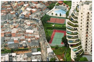
Higher finishing the Gastarbeiter case study today, and then want to look at a forced migration. We have a video on Clickview which shows Rwanda, but wondered about using Hotel Rwanda , or parts of it, as it is very powerful. Powerful too, is the online game mentioned in the post title, click on the image and see for yourself what life is like in a refugee camp. For supported study, I want to concentrate on exam technique and we can hopefully use the Higher wiki, as well as having a look at the BBC's excellent population pages . Speaking of the BBC, there is an excellent link to Barrios in Caracas , which would provide an excellent homework, perhaps on the blog or wiki for s4 where we could compare and contrast this with Mumbai.
s2 are getting a little tutorial on how to make movies in Moviemaker, topics are earthquakes, volcanoes, tsunamis and fold mountains, individual case studies acceptable. I have been trying to think of appropriate tunes, but for volcanoes I can't get 'Firestarter' by the Prodigy and 'Go with the Flow' by Queens of the Stone Age out of my head, and on reflection, I don't think either would be appropriate for any movie showing scenes of carnage! Any help from your peers, elders and others by suggesting tunes either to me in class or by posting a comment here would be most welcome.
Finally, doing my Wednesday morning behaviour support spot tomorrow, some interesting ideas for students personal planning and self assessment from my regular stint here, which I will try to write about and also implement my own take on these later.

Monday, November 27, 2006

Sore throats, High Blood Pressure, all in a day's work...

Categories: Geography General, Writing and Assessment, Development and Health, Population, Rivers, s1 and s2
Strange day today, none of the lessons seemed to go exactly as I wanted them to, not with any disastrous consequences, but not quite as I had visualised them. With Higher, I felt as though something I thought would last ten minutes (cards) dominated the period and ended up with far too much of me talking (sore throat now). I was pleased, however, with the surname profiler and the response from this. Tomorrow, we are going to look more closely at a particular migration involving Turkish Gastarbeiter, the link to the original image, showing a Turkish festival in Berlin, is here . s4 appeared to enjoy the health checks, although we had a little less apparatus than I would have liked, and some of it was malfunctioning a little (originally, my Blood Pressure recording would have had me clinically dead-checked later and much to my relief it was normal range). Our only real enemy here was time, although we did get to putting health in a world geographical context. Will continue with this tomorrow, but also want to involve you in a student blog activity. With s3, I changed the plans a little, as the rivers images that I wanted to use seem to have vanished and used Tom Biebrach's materials posted a few weeks ago, which seemed to work quite well as a brainstorm on rivers and their valleys. If we get through the rest of this tomorrow, I'll split the class into teams for a Rivers Challenge Board. s2 did well in the mapping of plates, earthquakes etc, but again, I felt that this could perhaps have been clipped for better effect. s1 tomorrow have symbols Bingo, or maybe Noel Jenkins 6 x 6 storyboard, found here on Tony Cassidy's Radical Geography site.

Sunday, November 26, 2006

Organising oneself...

Categories: Population, Development and Health, Rivers, Environmental hazards, s1 and s2, Geography General

...is really what I'll be doing with my first round of classes this week. I left work, but there are all sorts of loose ends to tie up. Speaking of organisation, I am loving bloglines , it is saving me quite a bit of time preparing lessons, as any new posts on blogs are notified directly to me. I am going to suggest that my Higher, and perhaps Intermediate classes start using this. You could put my own blog and the (admittedly in need of an update) student blog on your list for feeds, and also blogs like the Higher Geog Blog, Geobytes blog and some others-I am sure your own research and links that I have put in some of the posts in this blog will help build up a good resource for you.
I have to discuss the one child policy article with Higher tomorrow and had a laugh after I had told them to look for exaggeration, lack of factual evidence, use of language etc. I turned away to hear one of my sixth year muttering that he had dropped English last year. Clearly not everyone appreciates cross-curricular links :D. I also intend to give out a few terms on cards (examples- religion, gender, shanty town, lifestyle, asylum, immigrant, regime etc) and use them as triggers for discussion of migration-What are the reasons for the move? Is it forced or voluntary? Is it long term, short term, intra or international and so on? I will also try to pin examples on the discussions for use in exam style answers. I am not in my own room tomorrow, but if we have ICT, I'll try to use the spatial literacy website which profiles geographical locations of certain surnames in Britain and offers a comparison over time.
s4 have been doing some work on development, and we are about to look at the impact of health on development, so its cross-curricular again with Biology. I have asked to set up some stations where pupils can measure their own blood pressure, pulse etc. I can test BMI, but I think I'll draft in a couple of teachers for that one! I'll then set that against averages. Now I imagine that most will be well within the range, but I then want to get them thinking about factors which could affect their own figures ( Supersize me anyone?). We'll then set that against a world map and try and speculate about relative values in different regions-some of the answers will hopefully bring out some interesting discussion points-Seemingly unhealthy populations in supposedly developed countries and vice versa, which will hopefully bring out distinctions between health problems in EMDC's and ELDC's, reasons for them and the impact on development. Or maybe I'm being wildly overambitious....we'll see.
s3 will probably use some river images to test your knowledge of processes and landforms, as well as a little thinking skills odd one out on Rivers. s2 will have an interactive mapping activity based on last week's work(Plate Tectonics, Locating earthquakes, volcanoes and fold mountains-just a whiteboard, a world map and the pen). I then want to show a Movie maker effort by one of Tony Cassidy' GCSE pupils on fold mountains here. The reason for this is that I want students to create some movies of their own which we can then show to the class, and, with students permission, host on the wiki later.

Thursday, November 23, 2006

Sunbathing in Quindao

Categories: Population, Rivers, Environmenatl Hazards, s1 and s2

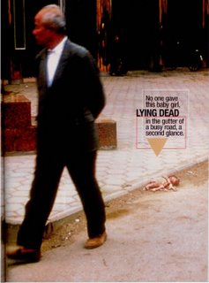
It's not Troon or Burntisland as I remember them, but I love this image of 20,000 people in Northern China cramming onto this beach. It is also an admittedly tenuous link to Population , China and the one child policy, which is hopefully where my Higher will have reached in my absence. If you have watched the video that I left, you should know that first of all, not all of China is like this (remember the work we did on Population distribution), and that secondly, although China's policy is seen as drastic and inhumane by many, population growth, if unchecked in China, would put serious pressure on resources. I want you to remember to be objective about this, so that you can consider the successes as well as failures of the policy. Using this article in some way should help-I flagged this up before I went off and if everything went well last week, we'll use it today.Be warned, this is quite disturbing. The image came from a blog, which may be very useful for Geography classes but I want to check the rest of the content first before putting it on here.I also want to stick this link from Rob Chambers' blog for the Hydrosphere section of the Higher course. The blog has some additional excellent material too.
Two things to finish. We are having real problems with Google Earth in its new format in the school at the moment, lots of blue patches appearing all over cities etc, so I said I would put up the link to the Google Earth file for s2 to look at from the comfort of their own home, again indebted to Ollie Bray for this. I have been very impressed with this. Used it one night and noticed a large magnitude earthquake north of Japan, and came in the next day to my s2 telling me about a tsunami in this area. I must read the news more... Secondly, I have a new s1 rotation who have now been here for a week, and am looking forward to getting to know them tomorrow. May do a word association game to check what they already know, and also to help me get to know names. Will then start putting subsequent lesson materials on here.

Clustrmap

Categories: Geography General
Back to work tomorrow, so been thinking about lessons etc. While browsing some of my favourite blogs for inspiration, I noticed a clustrmap was featured on several. After reading Ollie Bray's comments on these, and a point made by Rob Chambers on one of the forums I visit, I decided to add one to the blog page. A month or so after I started this blog I put a statcounter on it, basically to justify to myself whether this was a medium which students were willing to use or not. One of the features of the stats counter is an indication of the location of the visitors to the blog, and although the vast majority obviously come from our local area, I have had visits, most recently from Portugal, Brazil, Morocco and Thailand, as well as regular visits from the USA. Many of these visits last no time at all, but some stay around for a wee while. The map means that you can view visitors location at a glance(cue a dramatic drop in visitor numbers..). If nothing else, it shows how communications are making the world a much smaller place. The most ironic stat I have had so far is when someone had a look at some of the links we were using when doing Call Centres in India with s4. The location of the visitor....India!

Tuesday, November 14, 2006

Northern Lights?

Categories: Population, Development and Health, Writing and Assessment, RiversWas looking at the Rich Allaway's excellent site from the International School in Toulouse, and found this image of the Earth at Night. I think this is a great shot for Population Distribution, but also has links to Development and Urbanisation too, really highlights the imaginary North/South Divide and I may use this with s4 when they are back from work experience. Lots of links from the above site for tomorrow's double period. Linking to the Population Explosion exercise, we looked a little at how different regions of the world have a markedly different age concentrations. In the exam if you're asked a question about age structure of a country/region, it will probably be accompanied with a population pyamid. We'll look at how to describe the pyramid using classtools to take each part at a time. We'll then look at the difference between an ELDC and EMDC pyramid, before trying some bits of this worksheet. If we have time, we'll look at the Demographic Transition Model, and I'll get some blanks out to build up gradually as we talk through it. This link is in case I don't get to go through some of this on Thursday, some excellent info about ageing populations.
My s3 put up some rivers info on the wiki, and I noticed two or three changes have been made tonight. Well done, keep this going. Be mindful of plagiarism, and anyway you learn much more if you have to think about what you're writing. I will hopefully get the opportunity with s2 for a period on Earth Forces on their wiki too, as about a third of the class will be out at a science fair.
Favela lessons once gain a resounding success, glad I took the headache pills though! I forgot the mobile, but Miss Green has taken some photos of her class's attempts and I'll take the camera in tomorrow.

Monday, November 13, 2006

Flash and Explosions

Categories: Urban, Industry, Population, s1 and s2, Writing and Assessment, Geography General

'Flash Earth' in your browser window


Not long ago, Ewan_McIntosh posted a piece about FlashEarth , which may be a good way for people without Google Earth to get some high resolution satelite images. Since it only gives the overhead view, I have not been using it for classes doing Physical Geography, as I feel Google Earth is better here. However, when we do Urban work, this will come in handy. I remember using the Belfast map with some classes last year, and here is a link to one of my favourite places , the Harland and Wolff cranes which always to me signalled the start of any holidays taken in Ireland. If you pan out on the Google maps option, there is a whole array of urban and industrial Geography in clear focus, which could really help with the mapwork. Mess around with the different maps, find a place which means something to you, or just find your house. On the Microsoft maps, I can just about land in my back garden. I will post on an application called Virtual earth later.
The Population Explosion work that Higher completed today is the quietest that I have ever seen this class. I will tell myself that you were all so engrossed in the task :-) On serious note, I was really pleased with the amount of work that we got through, I thought that I was perhaps being a little ambitious in the amount of work that I set. I did the activity for myself, and it's very depressing when you learn that you can no longer be considered young...Anyway, more on population tomorrow, a little feedback on the activity, some discussion about young and ageing population and a couple of thinking skills activities.
Favelas being built by s1 tomorrow, should probably have warned the cleaners, hopefully as succesful as the last time I tried this. I'll post pics tomorrow on the blogs. Started a wiki for investigation work today with s3, never really got the chance to do a lot, and had to post a little note about plagiarism too! Hopefully, we can get this sorted in the next few periods, I spotted a couple of free ICT rooms with the s4 work experience, so we'll try to add to this tomorrow.

Earth Forces starter

Watch the video
for s2 starting earth forces unit

Sunday, November 12, 2006

Earth Forces meets Favelas...


Categories: S1 and S2, Writing and Assessment, Population
Well, not really, but if my s2 and s1 were to combine tomorrows topics, that's exactly what we'd get. After a time studying Japan, we are moving on tomorrow to study Earth Forces, after a class request for this to be the next topic. I have made a short starter movie, which I'll try to save to blip . Basically, I want students to try to think through some of the images to give us a basis to start the topic. I have also been looking at how NeilGood has been using a wiki with his s4 class. So far we've been using the wikis for collaborative exam answers, but I think that they would be excellent for opening up investigative topics to students and giving them a bit of control over their own learning. I have set up one here for s2, but I can see the value of this for almost every year group, and I fully intend to start one with s3 tomorrow (providing the school server doesn't block this!). With s1, I have split the image of Sao Paulo that I have already posted for a period starter, where I'll ask the class what links the two images, after which we're looking at Rio and Rocinha (Google Earth and the video). This will prepare us for the Favela project we will be completing in one lesson this week. Higher will be looking at this worksheet from Geointeractive-the labelling suggests it is for KS4, which would pretty much equate with Intermediate level study, but having looked at the content, there is a lot of relevance for Higher, and could be good prep for the demographic transition. s4 are all on work experience this week, but I'll try and post on next week's work at some point as I won't be in school Monday to Thursday next week.

Thursday, November 09, 2006

ClickView

Categories: Geography General
I mentioned in the last post that the school are trying out a new piece of digital video software. Basically, there is a bank of pre-installed video clips under subject headings. I searched through these and found as many Geography related films in the sciences section as in the Geography one. The device, ClickView(link above) also allows you to store your own departmental DVD's which can be copied into subject areas, as well as any Movies that you have made yourself for use in class. I have been having a quick browse at the website, and see that through this you can subscribe to certain podcasts and can import image collections. The possibilities here for easy management of all of the Geog departments multimedia resources are obvious, but here's what I want to know from students over the next few weeks...When we use the video bank clips and/or teaching resources which are included, what is the overall opinion of the quality, relevance etc of the materials? Secondly, we will be trying to use this over the next few weeks, and I have noticed there is a 'schoolbag' function. Once the software has been rolled out across the school and more resources are on this, how functional is this and how useful have students found it-in other words, is it getting used because I'm asking you to, or do you genuinely feel that there is merit in using it? I will speak to Higher about this tomorrow, as I'm going to try one of the population clips on it. I don't know yet how I'll collect the feedback. SurveyMonkey is becoming one of my favourite tools, and I hope to post the feedback on the Japan Unit and the Biscuit Game onto the student blog-we haven't quite collected all the feedback yet, more to do with my laziness in posting the links here than anything else. Anyway, back to marking NABs....

Wednesday, November 08, 2006

Change for the better?

Categories:Population, Development and Health, s1 and s2, Coasts
Very busy time at the moment, with Miss Green off, Higher sitting the NAB, and a change in the s1 rotation coming up. Also been doing work for a wee presentation to staff last night, and been playing around with something called ClickView, which we have on trial. Just posting links tonight-A Christmas Carol style, with past lessons, present and future. Higher population and s4 development and Health-used something similar to this the other day with s4. Links for Higher include the 6 million human beings site , which I will probably have to wait until Monday to use. Terminology help here for what we are doing just now, and a good scattergraph creator here. There are no doubt some links that I have neglected to post, but we'll get them on here eventually. There are also a couple of images which could be used with some classes tomorrow or later. For Higher, there is a shocker in this article about the one child policy, although we could use the piece for a critique, a suggestion mooted by Noel Jenkins on sln. There is also a great picture here, which I have cut in two for use with my s1. For s4, I am hoping to do the Trading game to supplement the work we're doing on reasons for differences in development. This link is as much for me as you, as I have lost the paper copy of this I had. I am trying to push on with coasts with s3, no links, but I'll need to scan the Swanage map for use on the whiteboard tomorrow. s2 will be playing Japanese Jeopardy, again no links as the file is at school. Made some progress with Japan links and will also put my surveymonkey feedback from the Japan unit on the student blog if I get time.....

Sunday, November 05, 2006

World population

Watch the video
Education vid for Higher

This video was originally shared on blip.tv by Kenny with a Creative Commons Attribution-ShareAlike license.

You're only a number....

Categories: Population, Coasts, Development and Health, s1 and s2
...and last time I checked, you were one of 6,662,087,901 people, currently crowded on to this rock. I will be asking Higher a good bit more about this today, but we'll make it more of a personal thing-How many people were around when you were born? Check here . I think we'll also make a note of the figure at the start of the period-Almost a full day since the last reading, to see how things have changed. I will be asking the following questions:-
1) How do we get these figures?
2) Can we trust them?
3) Is the spread of people predictable, and why?
On the last point, this does build on previous work from last year, but I have tried to make this perhaps not as clear cut as it seems by creating a short video, above, to stimulate thinking about population distribution.
Spent some time searching for a Japan game online, as I have lost my pen drive with a Japan jeopardy game on it which I had made. When searching sln and the forum for some ideas, I saw this , which ought to get some strange looks, but also triggered me to look on Tony Cassidy's site, where I found this flash game, which very conveniently ties in with the part of the Japanese unit which we are finishing, Japanese industry. s3 have another period to complete the commentary for the 'Coast' programme, while s1 are ready to look at Brazil and Development. Which leaves my s4, where we will be doing some kind of indicators exercise (Could we use cards ?). We already know about the idea behind this, but would we get it right? And why are some of the values so different from what we would expect?
Last word goes to the student bloggers from s3 and Higher who have filled up the comments well in a great response to the blog homework. Still some numbers notably missing, people who would obviously prefer a formal written homework in its place (last chance)......:-)

Thursday, November 02, 2006

Survey Monkey


Categories: Geography General, Coasts, Rivers, S1 and s2
I said in the previous post that I would like to use Survey Monkey in some ways. The obvious way is for feedback on lessons, activities, projects etc, and I am inviting s4 to comment on The Biscuit Game here. However, there is a lot of potential for using this for things such as formative assessment, where classes can comment on work that they themselves have done, and evaluate their own contributions and how much they have learned, where they should go from here etc. In the current climate, where pupils are being given Personal Learning Plans and such like, something like this could be really useful...just a thought. We will finish the feedback from the groupwork which followed the Biscuit Game with s4 today. Higher are on a shift on Wednesdays at the moment, with double period, followed by supported study! I thought we would do something a little lighter today, probably walkabout talkabout from the traffic lights. We covered most of the main points raised in supported study and remember if you missed this, I can still pass on the materials used. I really liked the idea on the Geography at the Movies website for s3-If you follow the coasts link, there is an exercise for you to record your own commentary for the BBC 'Coast' programme. There is a template to work with, and I think we will insert the movie into powerpoint to record our audio. I haven't explored the idea of the Japan link up for s2 yet, but will have a talk to one of the deputes given the chance tomorrow. I would really like to let you make the Japanese Industry movie, but we will have to be mindful of time. One of my s1 are using pictures of the Brazil and Scotland football teams as a starter. This always brings to the fore some really important points about race, even racism and stereotypes, and although the first couple of times I tried this with classes it was quite hard to manage, I am glad that I have persevered with this. It gives s1 the opportunity to talk about real issues, and their responses are always quite surprising and well thought out. Might be a surprise for my other s1...