<body><script type="text/javascript"> function setAttributeOnload(object, attribute, val) { if(window.addEventListener) { window.addEventListener('load', function(){ object[attribute] = val; }, false); } else { window.attachEvent('onload', function(){ object[attribute] = val; }); } } </script> <div id="navbar-iframe-container"></div> <script type="text/javascript" src="https://apis.google.com/js/platform.js"></script> <script type="text/javascript"> gapi.load("gapi.iframes:gapi.iframes.style.bubble", function() { if (gapi.iframes && gapi.iframes.getContext) { gapi.iframes.getContext().openChild({ url: 'https://www.blogger.com/navbar/23069377?origin\x3dhttp://geodonn.blogspot.com', where: document.getElementById("navbar-iframe-container"), id: "navbar-iframe" }); } }); </script>

Odblog

A weblog designed to share Geography resources with students and colleagues

Sunday, June 24, 2007

Homer-san...


Categories: s1 and s2, Glaciation, Geography General, Writing and Assessment
Not long till the blog goes into storage for six weeks or so...still some work to get through this week though. I really enjoyed the Tokyo panorama exercise on Friday, and will definitely be trying this with the other s2 class also. This was an idea I wasn't sure about, in terms of how it would translate to the classroom, how interested you would be, and what the end results would be. I thought in the short amount of time I let you view the image, your results were tremendous, and I was really impressed with how you worked in teams, Well done! Tomorrow, I hope to use an episode of The Simpsons to flesh out some of the themes you have addressed in our introduction to Japan, and also your leaflets (ongoing). Thanks again to GeographyPages for links to Val Vannet's powerpoint, which we'll use (scroll down the page). I also liked the idea on the same site for origami quizzes- instructions for making found here.
Having some problems with voki for s4 recordings, I'm wondering if we should just use Audacity, and then convert the file to mp3. I also want to get this class working on an Alps wall display to replace last years. Alas, Gary's breakdancing masterclass will be no more....
s3 and Higher are still in the throws of Glaciation-Higher might use some voice too, after we have finished looking at mapping glacial features. s3 have a little textbook work to complete, but might do a little interactive quiz.
Finally, Advanced Higher did some questionnaire returns on Friday-managing to cadge a glass of water and a bottle of lucozade from sympathetic individuals along the way. Some thoughts on the questionnaire-didn't envisage having to use 'plane' as a category for 'How did you travel to...'! Also, some of the categories could be enhanced or improved, Depending on the weather (at the moment it's wild), we might do our last bit of surveying (Environmental quality), followed by the sketches mentioned in the previous post over the next couple of days, otherwise, it's time to evaluate..
I've also allowed other students in the authority access to the AH wiki, more on this later.


Thursday, June 21, 2007

The Biggest Field Sketch in the world....

Categories: s1 and s2, Glaciation, Geography General
Some of you may have seen or heard of this before, but I have just witnessed the most incredible feat from a guy called Stephen Wiltshire on video. He was flown round Tokyo by helicopter and then spent some time viewing the city before drawing the whole thing as a panorama...from memory! The amazing result is here. I thought it would be an interesting break in proceedings for s2 to do a (much, much, much) smaller version of this in groups from a photo of central Tokyo. Might offer prizes...
Speaking of amazing field sketches, I met a colleague at a course tonight who showed me some outstanding examples of building sketches from Advanced Higher students. The detail was almost that of an architect's drawings. We were going to do the questionnaire tomorrow,but I'm now wondering if it would be an idea to split the group for environmental quality surveys and some sketching and labelling, as several class members are away at primary sports days.
Finally, with Higher, I'm going to try some O.S. overlays on Google Earth to map glaciation features along with a couple of other bits and pieces to finish. We'll spend a bit of time on the whiteboard with this.
On a personal note, every summer, I get totally engrossed in the Tour de France, a remarkable feat of endurance, sadly some of it sustained by doping in recent years. There is a write up on the Google Earth Blog on this year's race route in Google Earth. Download the kmz file here. There is so much Geography in this race, which starts in London this year, and I always love the mountain stages in the Alps and the Pyrenees for scenic value, test of the athletes, and spectacular crashes! The Alps are now really high resolution in GE, although the file does not yet show the mandatory brits in their club football jerseys insanely trying to get on camera as they chase passing cyclists....

Tuesday, June 19, 2007

Scottish fieldwork = rain


Advanced Higher are out again tomorrow, hopefully minus the rain. We completed a shops and offices survey today of a small commercial area (one of the pics above), but need to tidy up the transect. I took some photographs, but would like some more tomorrow- I am thinking of using these as a simple annotation exercise to compare building quality, style etc. I want to have three or four survey points for traffic tomorrow, and we'll get very little other than this done. On Thursday, I want to spend some time evaluating our fieldwork-what problems arose from the collecting techniques, how could these potentially be overcome in future etc, what have we proved/disproved, before doing a shopper questionnaire on Friday afternoon. This means at the start of next week, a couple of periods max should almost give us the basis of the human fieldwork NAB (completed after we have done stats) and more importantly, gives us practise for the study and the techniques you'll perhaps use. I am very keen to encourage the use of mobiles in the fieldwork, so please bring these tomorrow.

With Higher, I want to spend a period of the double tidying up glacial features, followed by some feature id from photos for deposition, a quiz on your internet research, maybe some back to back, and heaven forbid, some textbook work.

s2 are still researching Japan for their leaflets, which some people may be about to start tomorrow. Well done to s4 today on their prep for the Voki task. I noticed that there seems to be a problem recording with the mic at school, so I'm going to trial phoning this from the mobile tomorrow. I'll let you know how this goes...

Monday, June 18, 2007

Not quite us, but...

Categories: geography general, urban, rural, glaciation
...as AH are out on (much less complex) fieldwork in the urban area for most of the week, I'll be leaving some bits and pieces on the wiki for you to contribute to over and above your classwork. This is something that you'll all need to have a look at, as it influences the fieldwork we'll be doing Thursday and Friday. Having looked at the questionnaires, and also your criticisms of them (you were very perceptive about the good and bad features of other people's surveys), you hopefully realise that creating a good questionnaire is a really difficult skill. I am going to place some of the questions with your comments on the wiki page under the GMT's section. I'll leave some instructions tomorrow, initial your comment so that I know you've contributed. Meanwhile, here's something which might help along with the presentation I gave and that we discussed in class on Friday( thanks to Highland Learning).
For tomorrow, we are only going to have time to do a simple shops and offices survey , but I also want to a) over the next couple of days record a transect, and b) stick some photos on the moblog from the field.
I've booked in s3 and s4 for extensions to yesterday's tasks. The voki task for s4 has an update- I found out that with the text recognition, you get very little speaking time from your character, so we can either record vai the mic (60 seconds), or as you are in groups, record opinions from within the group seperately through different characters. We'll discuss this tomorrow, my own thoughts are that it would be less complicated if we just recorded the 60 second soundbite, but I know how protective you are of your dulcet tones...
Higher are working on glacial deposition, hoping to find an ICT room, if not, some booklet work for consolidation.


Sunday, June 17, 2007

New Wiki (again..)

Categories: Writing and Assessment
I've set up another wiki, this time for Advanced Higher. I want you to try it out by uploading your questionnaires which should have been completed over the weekend, which we can then critique and distill the good bits to finalise one that we can use for fieldwork purposes. You'll be familiar with how to use the wiki from Higher. I'm also thinking that, as you should really keep a field notebook, could this be something you could blog about? I'll canvass opinion tomorrow.Remember your consent forms, these will mean that most of this week, we can be out and about, practising skills which will be really useful for the Study later.
Higher are finishing glacial erosion and beginning our look at deposition, so might use some kind of research and peer teaching task. I used this last year, and it seemed to work quite well, and I'm aware that you have heard a lot of my voice over the past couple of periods, so this might break things up a little. I'll put a time limit/word limit on the explanations, and might have some kind of recap task at the end involving all of the features (probably takes us into Tuesday).

Voki greetings

Categories: Geography General, Rural, s1 and s2, Glaciation


Get a Voki now!

Rob Chambers has started an excellent new blog for using ICT in Geography. He posted tonight on a 'talking head' type application, which I've introduced here (an anime greeting for s2!), but hope to use more fully with other classes. Providing we can access this in school, I would like to use this with s4 tomorrow to create characters to help us answer the question 'Has the Green revolution in India been successful?'. These might include a farm labourer, a farm owner, an Indian government spokesperson and so on. We'll develop it in class, spend some time preparing our arguments and hopefully, publish! I would like to see the arguments being presented, followed by some kind of online vote. Maybe one for the student blog. I might also let s2 have a little play around with this, as there's a good link to Japan ( something that can perhaps be used in later presentations?). Keep being creative as well for the leaflet you're making, some really good ideas so far.
I think with s3, I'm going to let you find out a little about glaciation for yourselves, perhaps working in small groups for certain topics- e.g. freeze-thaw, corries, aretes etc, and in your own words, present back to the class through the s3 wiki . Maybe a quiz as follow up to ensure a) accuracy, and b) that other class members have read all the groups work as well as their own.


Thursday, June 14, 2007

What makes a good questionnaire?


Categories: Geography General

Tomorrow, I'm hoping to get Advanced Higher outside in some way, shape or form. I've been thinking about some fieldwork in the run-in to the holidays, very local, and wondered what you thought would make a good questionnaire? I had a look at my own surveys that I have created over the past year and have probably been guilty of some crimes in questionnaires-leading questions etc. I want to show you some examples of good and bad questions and see if you can spot the flaws, and may also allow you some critical reign over mine...and also to see if you can spot which questions are open, closed or scaled. I mooted the idea today of setting up an AH wiki page. It would be good to put some of the questionnaires here for others to evaluate before the Geographical Study, but I also think this would really help in organising and collaborating on coursework. Watch this space.
I'm not sure my lesson with s3 worked so well yesterday, I thought that although I was clear in my own mind what I wanted to do, I didn't really convey it that well to you. I'll try to revisit this on Monday from a different perspective. Higher continue tomorrow with glacial erosion and s2 with Japan leaflets, thanks for the Japanese greeting today, performed without prompting, which lightened a very heavy, and at times monotonous day for me 8-)

Wednesday, June 13, 2007

Extreme Plucking

Categories: Glaciation, s1 and s2, Rural
Feel that Higher went quite well today, not a lot of writing but a lot of consolidation. I'm putting the powerpoint with all the screenshots from Tuesday below. I was pleased with the hotseat attempts today, I know this was a bit unfair, but I think you all managed to pick up a lot of information about glaciation in a short time by doing it, and this should certainly make the rest of this topic a lot easier, well done. Tomorrow, I'm on to feature formation with you-we'll check over the book work first and then do a little glossary type revision of today's work-what is neve, basal sliding etc, then some diagrams for, hopefully, corries, aretes and pyramidal peaks as we start with features of erosion. Here's your attempts at labelling pictures:-


s3 are also starting Glaciation tomorrow, I'm wondering about doing this from a photo mystery activity, a 'What happened here?' type of question. Since I'm using Alps photos galore just now, I'll also need to do an evaluation of the trip with the appropriate people-I need to send a trip evaluation to the Education department, so I'll try to see you all tomorrow for a few minutes. Regarding s4, I would like to do a little bit of work on the wiki if we can get the PC's booked. I haven't really used this much yet at all with you yet and would like to get you using this as regularly as the Higher have over the last couple of years.
Good fun as ever with s2 doing our Japan intros. The Japanese greetings were exemplary, and hopefully you do well researching your family tree as Japanese names . Tomorrow, I'll introduce the leaflet task to you, and let you get started on the research.

Tuesday, June 12, 2007

Mars Bar Glaciers

Categories: Glaciation, s1 and s2, Geography General
I was really pleased with the s6 Higher students today, particularly how quickly you were remembering key terms for glaciation. Tomorrow, I might do a mastermind round for some of the explanations your group were working on with you. I need to go right back to basics tomorrow-how a glacier forms etc, and I'll use two things to do this. I really liked Alan's idea of a year in the life of a glacier. I have used this site so many times, yet can't remember seeing this before. Im going to adapt this for use on the whiteboard as a drag and drop activity to suit the month-This can then make up the basis of a note. I then want to use a photo of the Bosson, which has loads of crevasses as the ice comes over the sheer slope. Mars bar treats as we look at how glaciers move and crevasse formation. Can't remember who had this idea, but used it last year with reasonable success-you can then show ablation in action as you eat it. Maybe a video, then some core work on features of erosion. Some other useful glaciation links on Geography Pages here.
Japanese language lessons for s2, and a little starter activity for this topic with two groups. Advanced Higher are looking at this year's paper, layout etc, and I might have more of a look at the Geographical Issues tomorrow.If Friday's weather is decent, double period at the end of the day sounds good for a little outing, but I'm writing this as the rain batters off my sun room roof, so we'll see...

Monday, June 11, 2007

Moblog updated, how about a game of football (USA style)?


Categories: Geography General, Glaciation, Rural
I have just spent ages sending all of my usable photos to the moblog . Unfortunately, there are loads of good photos I can't use, as you're all in them-although I had permission for photographs, I didn't have permission to put them online, hence no lake in Morillon, no group photos at Sixt fer a Cheval, and none of you trying to get onto French TV (sadly, no permission for that either!). Please feel free to have a browse, use the photos for your own purposes, or leave a comment on the blog.
I am going to spend some time tomorrow going over the map interpretation exercises I left for AH last week, as I think I over-estimated how much you would do in my absence... Hopefully in early enough to scan the maps for the IWB. I would like to get you out for a wee while soon practising some work in the field too.
With Higher, I think I am just about ready to start Glaciation. I noticed today that I have several sixth year crash Higher students, who have no prior knowledge of this, along with some really clued up new s5. I see an opportunity here for the class to get to know each other a bit better. I'm going to get a couple of s5 to brief the s6 students, followed by a brief Q & A session to the s6 open to the whole class. Topics might be linked to annotation of some photos, with a knowledge base to explain some of the features in the photograph.
I started the Green Revolution today after using the scenario choice exercise with s4 (see last post). We agreed that it would be impossible for everyone to leave the countryside in India as cities could not sustain the growth, while 'push' factors in the countryside made it difficult to see a future here. This got us onto whether an improvement in the countryside would lead to better living conditions and therefore less migration, so we are now examining whether the Green revolution actually achieved this. I also want to involve this class in some kind of Alps display to replace last years later this week/ start of next.
Finally, my new s3 (or my old s2) started the course proper today, and tomorrow, I really just want to map some physical landscapes (coastal areas, major rivers, carboniferous limestone and glaciated uplands) using the course support material as this is commonly the first question in the Intermediate papers.
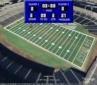
Now for something a bit lighter. If you have Google Earth, and you're a sports fan, I saw this on Google Earth Hacks earlier. Takes you to a sports field in the USA and lets you simulate a game of American football. Needless to say, as its a computer game of any sort, I was useless at it! You can download the kml here

Sunday, June 10, 2007

Where it's at...


Categories: s1 and s2, Geography General, Urban, Rural, Industry
I will probably spend tomorrow trying to readjust to school life and my new timetable after another excellent trip to the French Alps with four schools. My favourite parts of the trip, for the record- 1) Sixt fer a Cheval. With the exception of coasts, I could probably teach the whole Physical Environments unit from here. So much to illustrate a point, and visually unbeatable. 2) The Bosson Glacier- If ever anyone doubts the impact of climate change, they should visit this place yearly, as I have for the last three. We were talking to a French TV crew at the viewing platform who reckon its retreating at 20 metres a year. It looks a lot more than that to me. The whole left side of the glacier has really changed. I'll be putting pictures on the moblog-took the wrong plug to charge my phone, then had problems sending messages when I did charge it, so apologies that these did not go on during the trip. 3) Annecy, bowling and party. Just a great day, capped off by some very dubious singing talent by the staff. My biggest disappointments where both on Monday with the Mer de Glace tunnels being closed (I think it was for safety reasons), and then the luge being closed for another week-the opening times of this place seem so random. We went same week last year and this was on. Why don't you tell me here what you enjoyed?
Will no doubt spend a little time talking about this to classes, but here's the plans otherwise. I really need to go through course requirements and timelines with my Advanced Higher class. I think it's really important that we get organised early, and you should already have done enough to be assessed on some of your map interpretation (don't worry, not tomorrow). With Higher, you should have completed some of the lithosphere work that would have been less familiar to you, with weathering and mass movements featuring heavily. Show me what you know. I will use some word association, some labelling diagrams, some statement sort etc, before doing a pairs assessment task (answering, swapping, marking). s4 might benefit from this activity (thanks to Mez and Katharine from sln). It looks like a really good bridge between Urban, Rural and Industry, with our Indian case studies featuring. I will be able to introduce rural and industrial change in India as well as re-emphasising push/pull factors and urban problems. s3 will have a look at some images and link them as a course intro proper, while s2 will be asked to create Italy quizzes, a mini topic I used to introduce a lot of the s2 themes, before being asked to work on a poster presentation task. Lastly, I believe the p7 visits might be tomorrow, so I've created an introductory task above for download.