A weblog designed to share Geography resources with students and colleagues
Thursday, October 30, 2008
Last day of SAGT-ing...
Categories: Urban, Industry, Games and Quizzes This would have been the 11th idea from SAGT providing it had worked. I've created a quiz using content generator software. It's as a bit of Paris revision for s4 who have the assessment on Tuesday. If I manage to resolve the issues I'm having saving it, I'll edit this post to include it. If not, I'll have some variation of the activity in less tech-y form. I'm also including a dustbin drag and drop for Industrial Location from classtools. This, fortunately, I have been able to work :-s
Each activity is sandwiched by a past paper activity. I'm out tomorrow morning (and have a vast amount of reading to do for meeting beforehand), so I've left work for Higher and Advanced. Will talk to s1 about favela building activity period 6.
I'm using ideas from a SAGT presentation I didn't have the good fortune to attend for tomorrow's lessons. I use Google Earth a lot in the class, daily and across the year groups, but in all the lessons I've taught, I've never used the weather layer. Ollie Bray had a list of things to try in GE from his session on his blog, and I picked up on both the gallery and the weather layer. I also added the street view layer. Tomorrow when we are studying Japan, after our Japanese greetings, I think we'll have a quick weather forecast for the country.
Ollie had also indicated the usefulness of the gallery- there is just so much information on here. There is physical Geography through the active volcanoes, recent earthquakes and photographic content which are represented, and there are umpteen youtube videos, webcams, images, GPS tracks, panoramas and more to allow students to really explore. There's even a Kyoto city guide. I don't really think this would work with me talking to the class for any time about it. I think if I get the chance, I'll just let you explore in pairs for limited time slots.
Lastly, street view is a good way to explore the bigger cities. This is also available in Google Maps which all students should be able to access if we get a computer room. Certainly worth spending a bit of time on for your projects.
Categories: Rivers, Urban, Advanced Higher I was talking to the head teacher today about home revision and we were discussing a recent initiative at Alva Academy to provide revision vodcasts. I had actually read about this in an article in the TESS that I was given as a freebie at SAGT, so I suppose I can count this as idea 9 for the week. The work reminded me of something my own class had participated in a couple of years ago, but with a noteable difference. I gave a couple of boys some rivers footage with no audio and they recorded a script explaining processes, features and formation. So, after looking at Alva, here's an idea for Higher tomorrow:- 9) Instead of me recording a video tutorial for students, why don't we try to write our own scripts to go over some river slides? We could start with a rivers profile. The slides can then be saved as images and an audio commentary given in Movie maker. I wouldn't be able to get access to enough machines with moviemaker for a whole class exercise, but if I pick a good script or two, we can then have students providing their own revision materials and actively learning in the process. I think then I'll start with some video and maybe a short starter movie about processes before it in period 1. Some discussion, then the blank slides to a) Identify river features b) talk about dominant processes c) Compare upper, middle and lower course I'm going to talk to Advanced Higher tomorrow about fieldwork. At a meeting this afternoon, we were discussing the fieldwork question which is now compulsory at AH. I know you have completed shopper surveys, soil samples and river studies, but I think we possibly need more urban fieldwork techniques. I have been reading with growing interest the work of the Urban Earth project (see video above), and have been thinking of a possible way in which we could do something similar and the themes that you personally could develop for studies. There is some great potential for social and environmental geography in here. I have also been passing the Kittoch Water every day on my way to and from work, and there's a potential study theme there too as it's currently a building site for a flood scheme. Again, I'll chat to you about this in class.
Categories: Hydrosphere Here are some of the responses to my 140 character task from Monday. I have to say, most people found this very challenging trying to condense knowledge down to this size, but I am happy that at least for short time I had you really thinking about what you had to write! I never counted spaces. Some text speak and some real English thrown in along the way now and again:-
Precip = runoff + evap. All d precip finds way 2 grnd. D wtr in d grnd will reach field capacity 2 give surplus of wtr and rise in wtr tbl. Soil moist defic. = lil precip + lots evap
Chngs all yr, precip = evapotrans + runoff. Jan- May =surplus of H2O. May- Oct = soil moist deficiency. Oct-Nov = recharge
Open system, inputs r precip, output flows 2 C/lake. Rainfall caught in H2Oshed- outer limit of drnge bsn in2 catchment. H20 transfrd thru syst and stored. Size n shape influence r/o
H2O clecs in H2Oshed from lf drp, nfltrtn, precip. Then goes 2 rivr/ out of bsn thru runoff, thruflo, grnd wtr flw, chan flo. sum evaps, is intrcptd on way.
Some little innacuracies here and there, but in the circumstances, good stuff! There were more responses which were very similar to the ones above, so apologies if your work is not represented :-)
Categories: s1 and s2 Home a bit early today after a meeting, so thought I'd post up the response from s1 to the edited 'City of Men' clip. I started the lesson by flying to the top of the hill in Dona Marta in Google Earth, where the 'boss' stayed, and we had a brief discussion about the location. I had loads of great questions about favelas from the previous day and am just sorry I couldn't give time to answer them all, but this really seems to have fired the imagination. I then showed a Wordle where I'd pasted in the text from an article about someone who had been on three favela tours. I expected this to be quite positive. Here it is below:- I then set some work for the remainder of the period and invited students up to fill in what the clip made them think about in relation to favelas such as Dona Marta. This was very different:- My intentions are to look at both of these again after the topic is finished and simply ask for a judgement from students-which one is closer to the truth?
Categories: Geography General, Hydrosphere, s1 and s2
After all my conversion efforts, I got a mail at 2.30pm, ten minutes before I was due to teach my s1, that youtube had been permanently unblocked for staff use! Anyway, here's more ideas for use tomorrow. I'm cheating a bit here, as I've talked about both of these before, but different uses for them this time...
7) I hadn't planned to use this, but got a very random question from an s6 student today who asked me to name my favourite band -like the state The Simpsons live in, the clues are there if you look hard enough ;-)- This got me talking about the World Album covers atlas and a suggestion by Alan to use this as a homework with a prize for the first entry. I said I would make a small concession to s6 on Wednesday with this, as one was complaining that they don't get the fun stuff anymore :-( Might do this with Higher too. Thinking both of these year groups might have a more obsessive knowledge of their bands/ artists.
8) I liked the City of Men task today, and thought I might follow this up with a wordle based on what thoughts it provoked from students about favelas, which could then be displayed.
I'm probably out tomorrow afternoon, which means I'll miss Higher and s2. I'll try to put some text message answers from Higher on here and see who can decipher them. Brought them home to do, but flagging a bit tonight. If I'm out, I'll leave some hydrographs work, maybe using the images here as I've found that the link I used before to the doc is broken. If I don't use this may adapt this along with some textbook work. s2 continuing on research for leaflet, although seemed to be some interest in magazine style brochure.
At her seminar, Christine Lloyd Staples was talking about zamzar and how it could sometimes be slow. No kidding. I put a film clip in here last night at ten-ish, and I'm still waiting for it. So, I've been forced into idea 5 for use of my youtube clip:
5) I used media converter, as suggested at the seminar, and it was far and away a quicker solution to getting clips downloaded. Big bonus that the school don't filter it as well, as they have started doing with zamzar. I now have my clip, and was looking to resize it a bit, so...
6) I have inserted the clip into a powerpoint template given to us by Christine which has the clip playing inside a TV screen. Tap the screen and the clip begins.
I've also been developing the text message idea from before by introducing the lesson in text speak. This was through a recommendation made by Ollie Bray to use generators such as lingo2word ina previous article in the TES. Introduction above. Soundtransit went well first period, think I'll use it again if it guarantees the same peace and quiet!
Categories: s1 and s2, Hydrosphere, Geography General
I'm going to attempt to use either an idea a day or seven ideas in the week that I picked up from the SAGT conference on Saturday. Many thanks in advance to those who I'm about to rip off! So, here goes:-
1) Sound Transit - Via Alan Parkinson (as are the next two ideas). I thought since we have just started this topic, it would be interesting to challenge or reinforce some of the ideas we have about Japan with a short audio tour. Here's what I'd like students to think about- What image does the sound evoke? Where would they place the image (urban/rural)? Would this be something that personally would attract them to Japan, or would it have the opposite effect? I think this is important, as we are currently writing a leaflet geared to tourists. May, no probably will not use all:-
2) Since this is a Japanese Tourist Leaflet, I wondered if anybody would fancy doing theres as a brochure. Big Huge Labs has magazine cover templates that students may have some fun experimenting with.
3) As a starter with Higher, I think I'll use the text message idea. Here's what I'm thinking- Explain the hydrological cycle/drainage basins/water balance in 140 characters. Can it be done? I don't know, but it should make for interesting reading. Could be very useful as a revision technique too. Then, I'm going to have a look at hydrographs, something which, even at Higher, students will not have used, so I'll keep it simple, with a living graph starter, and then some work from the booklet.
4) From Christine Lloyd Staples seminar, I'm using zamzar for a yotubw movie(which I've done before) and taking her 5W's template for about the only useable clip from City of Men for s1- a great intro to favelas with good images of the streets, homes, a vivid exploration of the hierarchies and workings of these settlements. The excerpt is taken from 'The Mail' epsiode if anyone knows it. Technically, this might end up in Tuesday's ideas, depends how much I get through...
Other good things from SAGT- Miss McGill finally got to meet Dr Ian, and I enjoyed both his talk and that of Mark Beaumont, who made an epic journey around the world which was mapped by his former Geography teacherhere. Also nice to meet several colleagues again, some well known to me and others for the first time. I'm now off to watch some highlights of a different kind from Saturday :-)
Categories: Geography General, Rural Land Resources, s1 and s2, Games and Quizzes Had some good moments with my s1 today. We played a game at the beginning of the period, where students would catch a blow up globe and wherever their thumb landed, I would either give them a question, ask for a fact about the place or tell the class something myself. I ripped this idea off an old blow up weather ball that I had. After five minutes of this, I got some excellent work out of the class with very little effort from myself. Although I couldn't say the activity was a 'settler', I think students liked this as a concession to a period that was mostly textbook. Because of the purposeful work, we stopped a few minutes early and had a play with 360Cities , which I blogged about a couple of days ago, flying in through Google Earth. Unfortunately, only the European panoramas seemed to be working, so we'll revisit this. I absolutely love this through Google Earth. Was showing a colleague who's going to Paris a view of the city at night as though we were standing in the Eiffel tower. Amazing stuff, made more powerful when you are flying from place to place into street level. Tonight, Google Earth Blog had me back on Google Earth, this time through the browser, and really whetting the appetite for the Alps with a paragliding simulation. Watched Andrew Marr do this for real on 'Britain from Above' last night (see the video at the top of the post). He lasted an hour. I lasted about five minutes before trawling into the ground. Pretty good, though!
My lessons tomorrow are more formulaic, I'm afraid, although would like to let Higher see Rome in 360 as some visited recently. It's video time for the Water Balance and Drainage Basins, then some core work. We should know by now about field capacity, soil moisture utilisation, evapotranspiration, deficits and surplus amongst other things. Advanced Higher worked through a practice NAB today for Geographical Issues. Went OK, but I think one more period of sharpening our evaluations before the real thing. Which leaves me s4. We are doing Industry and I'd like to compare Old and New Industrial landscapes. It's either going to be a whiteboard exercise using images or a classtools one. I'm thinking either lights out as a whole class exercise, carefully analysing the landscapes, or if we can get the PC's, a Post-it exercise followed by a dustbin drag and drop for old and new landscapes.
Categories: Hydrosphere, Advanced Higher, s1 and s2
It's a late shift tonight, trying to catch up on time wasted on one of my less rewarding interests :-( Looking at last years stuff on Hydrosphere, and am going to use bits of this. I forgot to use the song today for novelty value, the moment may have passed, but I still think we should have a look at the wiki and make some alterations. Mark, amend, improve. Have a look at the terminology and compare it to what you have learned in the last couple of days.
I was also talking about the water cycle as a closed system- no water is put into or removed from Earth's available water, it is just recirculated. Drainage Basins, however are different. Different rivers and their drainage basins receive inputs from precipitation, and water is removed from the drainage basin as rivers flow to sea or it is evaporated. In a very, very simplistic way, it's a little like pouring water into a funnel. The water is there, runs through the funnel and then out. This is what we'll be looking at tomorrow, starting with the idea of what a drainage basin actually is. Taking the funnel idea, we''ll look at the lay of the land of some areas in Google Earth and see if we can correctly identify the watershed. We'll then compare a drainage basin to the hydrological cycle and look at inputs, storages and outputs. If we get time, we'll maybe then start looking at the factors which affect stream discharge in a drainage basin.
Advanced Higher-well, I'm going to have a look at one or two things, including an upcoming conference with some academics, politicians and pressure groups looking at issues such as energy, water etc which might give you some leads on your essays. We'll do a bit of critical evaluation on practice sources too.
s1 might have cause to use the globalrichlist, although I'm not quite sure I brought this in at the right time in today's lesson. I should have drawn attention to the fact that most of the students, even though the figures are 5 years old now, earn more from pocket money than 40% of working Brazilians do (and if anything like today's class, a couple will get more than the high earners too). This should help highlight the reasons why rainforest development is such a thorny issue.
One of the best things about blogging from a personal perspective is organisation. I know I taught roughly the same topics at the same time with most classes, and tomorrow, I've got a tailor-made lesson for Higher. One thing that I'll be adding to this is a little bit about the way humans can affect the water cycle. This is now in the arrangements for Higher, so could come up in the exam. We mapped from memory today for the Hydrological Cycle, something which has always worked well with previous years, but I felt the class were a bit subdued. Hopefully, this was just because it was first day back and nothing to be concerned about, and tomorrow's lesson should be able to assess the learning which has taken place.
I think with s2 tomorrow, I'll get you all by the end of the period to write your name in Japanese on your jotters, before giving a little family tree homework. We'll also go for some Japanese greetings and maybe some more Japanese language. I wonder if anyone would be willing and able to do some manga drawings. I think I have a book somewhere on this-some class caricatures? Or maybe you could FaceYourManga like the one above (which looks absolutely nothing like me!). This is a topic I really enjoy teaching, sometimes it's about pulling the reins in on myself here rather than the pupils!
For s1, 'World made by hand' exercises in tomorrow, some excellent efforts handed in already and clearly lots of work going into these-Well done!
I was having a flick through some of the links on Noel Jenkins excellent Teacher's Toolkit and thought that Visuwords would be a great starting point for a topic. S2 are beginning the Japan unit soon and one of the first things that you do is research for a leaflet. I put 'Japan' into Visuwords (click the image above for the results) and got a mass of useful things which could be used by students, along with an explanation when you scroll over them. This will definitely be getting an outing in classes this week.
Categories: Advanced Higher, Rural Land Resources, Hydrosphere, s1 and s2 I have had a rethink about Advanced Higher tomorrow after looking back at where I was last year. By this time, we were well down the road with our issues essays and had, I think, completed the issues NAB. This week therefore, I'm going to dedicate our time to doing just this. Tomorrow, I'm going to do a quick tutorial about scholar and google alerts as mentioned a few posts ago, and then I'm going to spend some time with individuals sorting through what you've got. By the end of the week, I'll be looking for what you're chosen issue is, what sources you are using and a very brief summary of the viewpoints. I'm going to expect much more of this to be done in students own time this year as I felt last year it became too much of a classroom exercise -there's too much to do to give over that amount of time again, I think. Higher have a small bit to do to end rural land resources, and then It's straight onto the Hydrosphere, The Hydrological Cycle and memories of last year's inspection (doing the exact same lessons at the time the inspectors walked into my room). We'll be mapping from memory with a follow up task on Tuesday. Some good stuff here for your revision of this topic when the time comes. S2 have anEarth Forces assessment-hope you have remembered, and s1 are still looking at how developed Brazil is. On a personal note, I really need to post some of our work to our link school, so this will be taking priority tomorrow. See you all in ten and a half hours :-)
I was intrigued by the Word Magazine Album Atlas recently, as blogged elsewhere by Alan Parkinson. I haven't used it yet at work, but it's worth a look even for your own interests. I was checking another site tonight and saw this photo:
Really strong urban scene, and certainly doesn't look like an area that has benefited from regeneration. This building does however, have a history as an album cover. I wonder if anyone knows the album? I can think of someone who has only recently left the school who would have got this straight away-he liked his seventies rock giants!
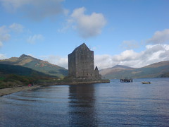
Categories: Urban, Geography General I blogged yesterday about a tour of Paris and panoramas which could be opened in Google Earth. Google Earth blog has married the two, including a youtube video showing how effective the panoramas are:
This is even better for teaching Paris at Intermediate.
Categories: Geography General Have just returned today from a short break and my feed reader is full of useful things for returning to work next week and beyond. One of the best things I looked at was 360 Cities, which will be brilliant for the Japan unit we are beginning with s2 this week. Just spent some time seeing Tokyo in moveable panoramas, and then visited Riga in Latvia, a city a friend of mine never stops raving about-easy to see why looking at some of the 360 views. The panoramas can also be opened inside Google Earth. Thanks to Ogle Earth for the info on this.
Still with Google Earth, I also, through Twitter, was drawn to a tour of Paris. Pretty much all of the major tourist landmarks are here, and might be a good way to introduce Paris for Intermediate Urban. Thanks to Keir Clarke. Ollie Bray also highlighted a good site for images of industrial landscapes, which will keep for now, but will be handy for Higher later. He also in earlier writings spoke about Google Scholar. I had a quick look at this and it will be really valuable for use with Advanced Higher, particularly for sourcing the kinds of articles which are credible for your Geographical Issues essay. Ollie also reccomended the use of Google Alerts,which his Advanced Higher have benefitted from too. Many thanks for both of these ideas, Ollie.
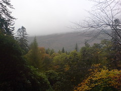
While away, I saw the good and bad of the Scottish weather, with fine conditions on the West Coast on Thursday:
Followed by Friday and lashing rain, with low cloud never far away:
Holiday almost done. All I need to do now is sort lessons for Pearson's product, development in Brazil and a bitty lesson to end RLR for Higher :-( . Off to watch match of the day instead...
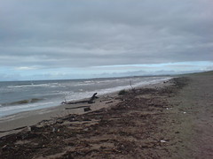
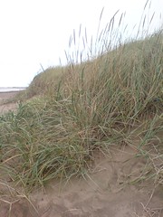
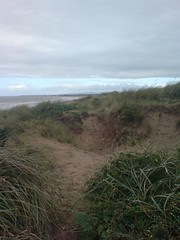
Categories: Coasts I was recently involved in a discussion which had me questioning my knowledge of coasts. A query had been posed about beaches and beach profiles. I had always been of the view that high energy waves (destructive waves) formed steep beaches and low energy constructive waves formed gently sloping beaches. This link seemed to confirm everything that I had thought. In hindsight, after some responses to the aforementioned question, I now think I have looked at this from a very simplistic viewpoint. For instance, what would the influence of a headland be in the energy of waves reaching a bay? Would it not act as a wave break in a way? A colleague also made the point that high energy waves with a strong backwash, although dragging material out to sea will, by depositing it in deeper water, eventually create sediment bars which will lead to shallower water, earlier breaking waves( still the same high energy waves?) and more deposition. Maybe I've been getting too bogged down in what happens during storms to the coastline, but I have to admit, I'm still a little confused as to how I'd teach this without muddling the minds of my classes (more than usual :-0). Today, I had an urgent errand to run which fortunately resulted in myself and the kids heading down to Prestwick beach after it. It was freezing, the waves were big, the beach wide and flat, the dunes high and debris everywhere at the shore. I couldn't help thinking about the discussions I'd had just a few days previously, and hopefully my own knowledge of coasts has been improved as a results. For anyone who's ineterested, here are some videos and photos of the beach and sand dunes today:
and finally, for my boy, Paddy's Milestone, Ailsa Craig from the shore - gave my story about a giant throwing it much more credibility when I showed him it!
Categories: Geography General, Environmental Hazards, s1 and s2, Rural While I was reading some blogs tonight, Val Vannet had highlighted Britain from Above on the BBC. The programme has been on TV recently, and clips can now be embedded into blogs. Val flagged some good rural resources, and I found this below bout the Great Glen Fault, something I was talking to s2 about recently. Some really useful resources, thanks Val!
Categories: Geography General Was looking through my bookmarks tonight and found something very cool that I'd forgotten all about, Yahoo Soup. Haven't really thought about this for the class before, but had an idea while messing around with it. This would be a great way to introduce a location. I had been talking to someone about Quebec at the weekend and realised how little I knew about it, so popped Quebec into Yahoo Soup, searched for the tags (quite hard) and then searched the photographs. I now have a much better idea of the 'look' of Quebec, from virtually nothing. Try it for yourself
Categories: Writing and Assessment, Rural Land Resources
I spent some of today's Higher period putting guidance on the wiki page where answers could be developed. In general, the answers needed more exemplification and were a bit disjointed, but don't worry too much about that, it's early days. Please feel free to go back and improve what we've got.
Blogging this at the end of interval, having did this with my s1 last period. Started the period with a discussion about Brazil's resources, asked pupils to remember that resources were not only a local or national concern, but a worldwide concern. Gave pupils the scenario detailed- no oil, resource shortage and violence, climate change acceleration etc. 5 minute discussion time in pairs on what things students would miss, then feedback to class:
Then, posed the question- would it be such a bad place? What would they like about their changed lifestyle?
Lastly, an activity geared towards our link. Our poartner school has asked to do something on environmental change, and thought we could send some examples of written work:-
I initially had fears about this lesson, but they appeared unfounded, and the class responded really well to the activity. Well done!
There have been some fantastic mapping applications available lately, and another very useful one was brought to my attention by Google Earth Blog. Earth Atlas uses Google Earth in the browser and opens a variety of layers. Some old favourites for me here such as the live earthquakes layer, some good statistics, and the ability to add other google earth files from the web. I'll be using this in class with s4 when doing development, and it might be useful for AH too, depending on your Issues essay.
Categories: s1 and s2, Geography General, Atmosphere
While browsing one of my favourite websites tonight, I saw mention of a book called 'World made by Hand' by James Howard Kunstler. The book is futuristic, and paints a worst case scenario of what the world would be like with no oil, rapid climate change, worldwide disease and resource wars. This sounds nightmarish, but the book also has a soft centre. A world of no traffic, people living off their own land, rivers full of fish... I wonder what students would make of this. I wonder what your imagination would lead you to if you were asked to envisage such a future. What would you miss? Would your world be a better or worse place? There is scope for some fantastic extended writing exercises here. I could wait and use this idea with s2 during Environmental Issues, but there seems to me to be a good link for s1. Today we started picking at the idea of Brazil as a rich or poor country. During this, we also looked at Brazil's enormous resources and some of the issues in exploiting them. This could certainly be extended to a worldwide level and then brought back to Brazil and how one person in one country can have an impact.
Categories: Rural Land Resources, Coasts, s1 and s2 The Higher on Friday was pleasing, with some good results from our group exercise period 2 of the double (I'll start the period tomorrow with a bit of feedback), and a chance period 1 for me to sit with individuals and chat about progress, which is always welcome. Tomorrow, we start the coasts part of Rural Land Resources. Again, nothing absolutely new here, but getting your examples sorted is again the key. Cue old powerpoint from two or three years ago:-
On of many things which will no doubt be blocked yet again in school with changes to the filter, but I've got a copy at school, this is just for revision. Also, very pleased with the recent use of the wiki, small and large changes alike. Some corrective work can be done on the whiteboard by me while you work on some of the booklet work, saved and then posted here hopefully (or maybe posted on the wiki?)
Last, but by no means least, s1 are looking at the theme, Brazil:Rich or Poor? I had a good lesson with my other s1 using a serious of images from around Brazil-some great discussion, and also some very observant pupils! Some of the images were related to Brazil's resources and this one came up
For s2, I have a preferred option and a reserve option. Plan A-my preference- is to do two things throughout the period. It very much depends on accomodation. I'd like to take s2 to the computer room. First thing we'll be talking about is something I shelved while we got through the content of Earth Forces, your disaster movies. I will, as requested, give a run through of how to use movie maker, but in case you forget bits, or are not present, here is a video tutorial from Adam Lawson;
Tutorial1 from geogdocs on Vimeo. Other tutorials available here. I've already shown previous student efforts and the quality is usually very high, so we'll look at a week as the timescale for you finishing these at home/ in school. Secondly, I would guess we'd have at least 20-30 minutes left after this, time enough to allow you a go at the stop disasters game, something of a tradition now. Might get you to print screen and submit a score to see your name in lights! Failing Plan A, although it's something we've briefly discussed, we haven't dwelt too long on tsunamis, so we'll use a good video resource looking at the 2004 tsunami. There are accompanying activities, lots of good discussion points, and a homework activity to go with this. We are almost at the end of the Earth forces unit, so time to start preparing for your assessment...
Categories: Advanced Higher We're going to have a go at another stats techniques tomorrow, this time a chi square test. I think it's worth pointing out that last year I collected a lot of statistics links on my del.icio.us page, and it would be worth your while having a look at this. So, first up, we're going to forget numbers and go back to the familiar-glaciated landscapes. Mapping landforms. Corries. I think there are plenty of O.S. maps that would do the job for this, but it's really important that the map has at least 20 corries- maybe something like Keswick. Would we have any expectations about the direction these corries would be facing? We'll then identify the corries and the direction they are facing. Second- let's record some frequencies- not percentages. Use a protractor or a compass and work out the angles, make a quick table with four categories just like in this example. Right, now come the stats bit- a run through of this powerpoint, then putting this into practice on your own frequencies. This example will probably not be familiar to one that you would encounter in your own study's given our geographical location, but the technique is one that can easily be used in human geography- comparing the quality of shops, or the building type in two locations, for instance.
Geocommons, enviro-sceptics and names around the world
Categories: Advanced Higher, s1 and s2
Found some really useful student resources tonight on my virtual travels. I was directed to an excellent map maker through googlemapsmania. Geocommons allows you to use either your own data and/or the data listed through their site to create your own personalised maps. These can be represented through a number of techniques, including choropleth and proportional symbol mapping. I'm thinking that this would be an essential site for use with Advanced Higher projects, and saves ages searching the internet for a map which doesn't really serve all of your purposes. I'll maybe schedule a session to look at these on Friday.
Still with Advanced Higher, and I have a fantastic article courtesy of Stephen Schwab on sln for Martin's Issues essay, in case I forget to tell you! This is a great viewpoint regarding Britain's contribution to reducing global warming, and just the kind of strong opinionated article which you can really critique.
Finally, first year have enjoyed looking at their surname profiler and I am posting the link since many asked for this. We were looking at surname spreads as a link with migration, and later, migration to Brazil. As most expected, there were strong links to UK and Ireland, but it was interesting that many Scottish or Irish surnames (such as mine) show larger concentrations in places like Australia, New Zealand and the USA than they do inScotland or Ireland, and led into some short discussion about the reasons for this- the clearances , the famine, the language, family etc.